Wolferstedt geodata
Wolferstedt (Saxony-Anhalt) is a populated place; located in Germany in Europe/Berlin (GMT+2) time zone. With population of 757 people, there are 8061 cities with bigger population in this country. Compared to other cities in Germany, 65.2% of cities are located further ↓South; 73.3% of cities are located further ←West and 60.6% of cities have higher elevation than Wolferstedt. Note1


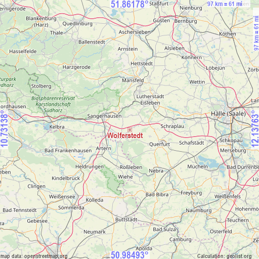
Wolferstedt GPS coordinates[2]
51° 25' 31.656" North, 11° 26' 4.2" East
| Map corner | latitude | longitude |
|---|---|---|
| Upper-left | 51.86178°, | 10.73138° |
| Center: | 51.42546°, | 11.4345° |
| Lower-right: | 50.98493°, | 12.13763° |
| Map W x H: | 97.5×97.5 km | = 60.6×60.6mi |
| max Lat: | 55.01917° ⇑34.8% North |
| Wolferstedt: | 51.42546° |
| min Lat: | ⇓65.2% South 47.40724° |
| min Long | Wolferstedt | max Long |
| 5.92978° | 11.4345° | 14.98853° |
| W 73.3%⇐ | ⇒26.7% E |
Elevation
Elevation of Wolferstedt is 148 m = 486 ft, and this is 101.1 m = 332 ft below average elevation for this country.
| Max E: |
1256 m = 4121 ft | 60.6% |
| Avg. | 249.1 m = 817 ft | |
| Wolferstedt | 148 m = 486 ft | |
Min E: |
-5 m = -16 ft | 39.4% |
See also: Germany elevation on elevation.city.
Geographical zone
Wolferstedt is located in North temperate zone (between Tropic of Cancer and the Arctic Circle). Distance of this North polar circle is 1683.2 km =1045.9 mi to North.| Distance of | km | miles | from Wolferstedt |
|---|---|---|---|
| North Pole | 4289.1 | 2665.1 | to North |
| Arctic Circle | 1683.2 | 1045.9 | to North |
| Tropic Cancer | 3112.1 | 1933.8 | to South |
| Equator | 5718 | 3553 | to South |


Nearby cities:
15 places around Wolferstedt: (largest is in red/bold)
• Allstedt
4.1 km =2.5 mi,  233°
233°
• Beyernaumburg
6.1 km =3.8 mi,  332°
332°
• Bischofrode
9.6 km =6 mi,  44°
44°
• Blankenheim
9.1 km =5.7 mi,  357°
357°
• Bornstedt
7.3 km =4.5 mi,  27°
27°
• Emseloh
9 km =5.6 mi,  340°
340°
• Farnstädt
9.2 km =5.7 mi,  84°
84°
• Holdenstedt
5.6 km =3.5 mi,  8°
8°
• Mittelhausen
2.1 km =1.3 mi,  63°
63°
• Mönchpfiffel-Nikolausrieth
6.6 km =4.1 mi, 225°
• Oberröblingen
8.9 km =5.5 mi,  278°
278°
• Osterhausen
5.8 km =3.6 mi, 56°
• Riestedt
9.3 km =5.8 mi, 326°
• Rothenschirmbach
8.5 km =5.3 mi,  66°
66°
• Voigtstedt
9.5 km =5.9 mi,  246°
246°
Sources, notices
• [Note1] Compared only with cities in Germany existing in our database
• [Src1] Map data: © OpenStreetMap contributors (CC-BY-SA)
• [Src2] Other city data from geonames.org with taken over terms of usage.
• [Src3] Geographical zone / Annual Mean Temperature by Robert A. Rohde @ Wikipedia
