Bischofrode geodata
Bischofrode (Saxony-Anhalt) is a populated place; located in Germany in Europe/Berlin (GMT+2) time zone. With population of 752 people, there are 8089 cities with bigger population in this country. Compared to other cities in Germany, 66.1% of cities are located further ↓South; 74.7% of cities are located further ←West and 58.5% of cities have lower elevation than Bischofrode. Note1
Administrative division(s):
- Level 1: Saxony-Anhalt
- Level 3: Mansfeld-Südharz
- Level 4: Eisleben, Lutherstadt


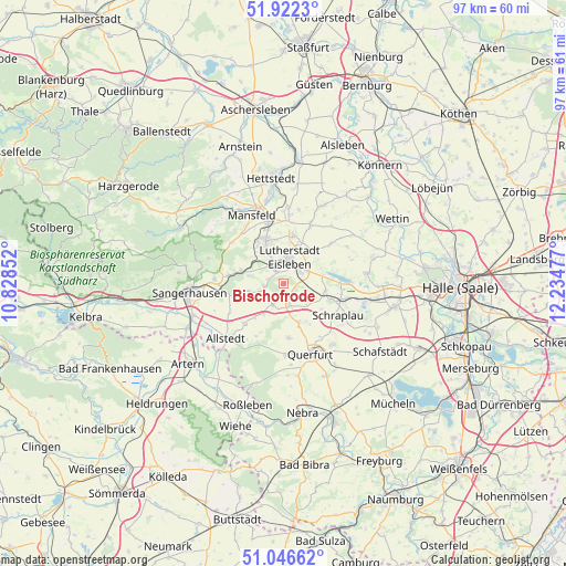
Bischofrode GPS coordinates[2]
51° 29' 11.616" North, 11° 31' 53.904" East
| Map corner | latitude | longitude |
|---|---|---|
| Upper-left | 51.9223°, | 10.82852° |
| Center: | 51.48656°, | 11.53164° |
| Lower-right: | 51.04662°, | 12.23477° |
| Map W x H: | 97.4×97.4 km | = 60.5×60.5mi |
| max Lat: | 55.01917° ⇑33.9% North |
| Bischofrode: | 51.48656° |
| min Lat: | ⇓66.1% South 47.40724° |
| min Long | Bischofrode | max Long |
| 5.92978° | 11.53164° | 14.98853° |
| W 74.7%⇐ | ⇒25.3% E |
Elevation
Elevation of Bischofrode is 281 m = 922 ft, and this is 31.9 m = 105 ft above average elevation for this country.
| Max E: |
1256 m = 4121 ft | 41.5% |
| Bischofrode | 281 m 922 ft | |
| Avg. | 249.1 m = 817 ft | |
Min E: |
-5 m = -16 ft | 58.5% |
See also: Germany elevation on elevation.city.
Geographical zone
Bischofrode is located in North temperate zone (between Tropic of Cancer and the Arctic Circle). Distance of this North polar circle is 1676.4 km =1041.7 mi to North.| Distance of | km | miles | from Bischofrode |
|---|---|---|---|
| North Pole | 4282.3 | 2660.9 | to North |
| Arctic Circle | 1676.4 | 1041.7 | to North |
| Tropic Cancer | 3118.8 | 1937.9 | to South |
| Equator | 5724.8 | 3557.2 | to South |


Nearby cities:
15 places around Bischofrode: (largest is in red/bold)
• Alberstedt
7.8 km =4.8 mi,  123°
123°
• Blankenheim
7.5 km =4.7 mi,  287°
287°
• Bornstedt
3.4 km =2.1 mi,  263°
263°
• Eisleben Lutherstadt
4.7 km =2.9 mi,  14°
14°
• Erdeborn
7.3 km =4.5 mi,  99°
99°
• Farnstädt
6.4 km =4 mi,  157°
157°
• Helbra
7.4 km =4.6 mi,  342°
342°
• Hergisdorf
6.2 km =3.9 mi,  327°
327°
• Holdenstedt
6 km =3.7 mi, 258°
• Lüttchendorf
6.8 km =4.2 mi,  75°
75°
• Mittelhausen
7.6 km =4.7 mi,  219°
219°
• Osterhausen
4.1 km =2.5 mi,  207°
207°
• Rothenschirmbach
3.6 km =2.2 mi, 162°
• Wimmelburg
4.2 km =2.6 mi, 335°
• Wolferode
2.6 km =1.6 mi, 329°
Sources, notices
• [Note1] Compared only with cities in Germany existing in our database
• [Src1] Map data: © OpenStreetMap contributors (CC-BY-SA)
• [Src2] Other city data from geonames.org with taken over terms of usage.
• [Src3] Geographical zone / Annual Mean Temperature by Robert A. Rohde @ Wikipedia
