Weißenhorn geodata
Weißenhorn (Bavaria) is a populated place; located in Germany in Europe/Berlin (GMT+2) time zone. With population of 13,377 people, there are 1196 cities with bigger population in this country. Compared to other cities in Germany, 91.2% of cities are located further ↑North; 52.6% of cities are located further ←West and 88.9% of cities have lower elevation than Weißenhorn. Note1
Administrative division(s):
- Level 1: Bavaria
- Level 2: Swabia
- Level 3: Landkreis Neu-Ulm
- Level 4: Weißenhorn


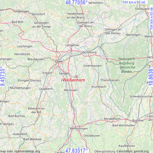
Weißenhorn GPS coordinates[2]
48° 18' 18.036" North, 10° 9' 37.692" East
| Map corner | latitude | longitude |
|---|---|---|
| Upper-left | 48.77056°, | 9.45735° |
| Center: | 48.30501°, | 10.16047° |
| Lower-right: | 47.83517°, | 10.8636° |
| Map W x H: | 104×104 km | = 64.6×64.6mi |
| max Lat: | 55.01917° ⇑91.2% North |
| Weißenhorn: | 48.30501° |
| min Lat: | ⇓8.8% South 47.40724° |
| min Long | Weißenhorn | max Long |
| 5.92978° | 10.16047° | 14.98853° |
| W 52.6%⇐ | ⇒47.4% E |
Elevation
Elevation of Weißenhorn is 503 m = 1650 ft, and this is 253.9 m = 833 ft above average elevation for this country.
| Max E: |
1256 m = 4121 ft | 11.1% |
| Weißenhorn | 503 m 1650 ft | |
| Avg. | 249.1 m = 817 ft | |
Min E: |
-5 m = -16 ft | 88.9% |
See also: Germany elevation on elevation.city.
Geographical zone
Weißenhorn is located in North temperate zone (between Tropic of Cancer and the Arctic Circle). Distance of this North polar circle is 2030.2 km =1261.5 mi to North.| Distance of | km | miles | from Weißenhorn |
|---|---|---|---|
| North Pole | 4636 | 2880.7 | to North |
| Arctic Circle | 2030.2 | 1261.5 | to North |
| Tropic Cancer | 2765.1 | 1718.2 | to South |
| Equator | 5371 | 3337.4 | to South |


Nearby cities:
15 places around Weißenhorn: (largest is in red/bold)
• Bellenberg
7.4 km =4.6 mi,  224°
224°
• Buch
9 km =5.6 mi,  170°
170°
• Dietenheim
12.4 km =7.7 mi,  212°
212°
• Ellzee
12.3 km =7.6 mi,  71°
71°
• Holzheim
9.8 km =6.1 mi,  332°
332°
• Illerrieden
8.9 km =5.5 mi,  244°
244°
• Illertissen
10 km =6.2 mi,  204°
204°
• Pfaffenhofen an der Roth
5.5 km =3.4 mi,  1°
1°
• Rieden an der Kötz
11.4 km =7.1 mi,  38°
38°
• Roggenburg
6.2 km =3.9 mi,  121°
121°
• Senden
8.8 km =5.5 mi,  284°
284°
• Staig
12.5 km =7.8 mi,  267°
267°
• Unterroth
12.2 km =7.6 mi,  176°
176°
• Vöhringen
6.5 km =4 mi, 242°
• Waldstetten
11 km =6.8 mi,  64°
64°
Sources, notices
• [Note1] Compared only with cities in Germany existing in our database
• [Src1] Map data: © OpenStreetMap contributors (CC-BY-SA)
• [Src2] Other city data from geonames.org with taken over terms of usage.
• [Src3] Geographical zone / Annual Mean Temperature by Robert A. Rohde @ Wikipedia
