Bellenberg geodata
Bellenberg (Bavaria) is a seat of a fourth-order administrative division; located in Germany in Europe/Berlin (GMT+2) time zone. With population of 4,607 people, there are 2983 cities with bigger population in this country. Compared to other cities in Germany, 91.8% of cities are located further ↑North; 51.6% of cities are located further ←West and 89% of cities have lower elevation than Bellenberg. Note1
Administrative division(s):
- Level 1: Bavaria
- Level 2: Swabia
- Level 3: Landkreis Neu-Ulm
- Level 4: Bellenberg


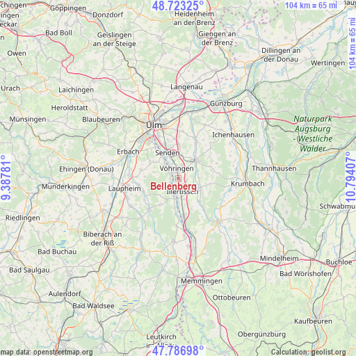
Bellenberg GPS coordinates[2]
48° 15' 26.136" North, 10° 5' 27.384" East
| Map corner | latitude | longitude |
|---|---|---|
| Upper-left | 48.72325°, | 9.38781° |
| Center: | 48.25726°, | 10.09094° |
| Lower-right: | 47.78698°, | 10.79407° |
| Map W x H: | 104.1×104.1 km | = 64.7×64.7mi |
| max Lat: | 55.01917° ⇑91.8% North |
| Bellenberg: | 48.25726° |
| min Lat: | ⇓8.2% South 47.40724° |
| min Long | Bellenberg | max Long |
| 5.92978° | 10.09094° | 14.98853° |
| W 51.6%⇐ | ⇒48.4% E |
Elevation
Elevation of Bellenberg is 504 m = 1654 ft, and this is 254.9 m = 836 ft above average elevation for this country.
| Max E: |
1256 m = 4121 ft | 11% |
| Bellenberg | 504 m 1654 ft | |
| Avg. | 249.1 m = 817 ft | |
Min E: |
-5 m = -16 ft | 89% |
See also: Germany elevation on elevation.city.
Geographical zone
Bellenberg is located in North temperate zone (between Tropic of Cancer and the Arctic Circle). Distance of this North polar circle is 2035.5 km =1264.8 mi to North.| Distance of | km | miles | from Bellenberg |
|---|---|---|---|
| North Pole | 4641.4 | 2884 | to North |
| Arctic Circle | 2035.5 | 1264.8 | to North |
| Tropic Cancer | 2759.8 | 1714.9 | to South |
| Equator | 5365.7 | 3334.1 | to South |


Nearby cities:
15 places around Bellenberg: (largest is in red/bold)
• Altenstadt
10.9 km =6.8 mi,  170°
170°
• Buch
7.6 km =4.7 mi,  118°
118°
• Dietenheim
5.4 km =3.4 mi,  195°
195°
• Hüttisheim
11.3 km =7 mi,  282°
282°
• Illerrieden
3.2 km =2 mi,  296°
296°
• Illertissen
3.9 km =2.4 mi, 166°
• Oberroth
11.6 km =7.2 mi,  141°
141°
• Roggenburg
10.6 km =6.6 mi,  78°
78°
• Schnürpflingen
7.5 km =4.7 mi, 283°
• Senden
8.2 km =5.1 mi,  335°
335°
• Staig
8.8 km =5.5 mi, 302°
• Unterroth
9.1 km =5.7 mi, 139°
• Vöhringen
2.4 km =1.5 mi, 344°
• Wain
9.2 km =5.7 mi,  214°
214°
• Weißenhorn
7.4 km =4.6 mi,  44°
44°
Sources, notices
• [Note1] Compared only with cities in Germany existing in our database
• [Src1] Map data: © OpenStreetMap contributors (CC-BY-SA)
• [Src2] Other city data from geonames.org with taken over terms of usage.
• [Src3] Geographical zone / Annual Mean Temperature by Robert A. Rohde @ Wikipedia
