Illerrieden geodata
Illerrieden (Baden-Württemberg) is a seat of a fourth-order administrative division; located in Germany in Europe/Berlin (GMT+2) time zone. With population of 3,320 people, there are 3742 cities with bigger population in this country. Compared to other cities in Germany, 91.6% of cities are located further ↑North; 51% of cities are located further ←West and 88.6% of cities have lower elevation than Illerrieden. Note1
Administrative division(s):
- Level 1: Baden-Württemberg
- Level 2: Tübingen Region
- Level 3: Alb-Donau-Kreis
- Level 4: Illerrieden


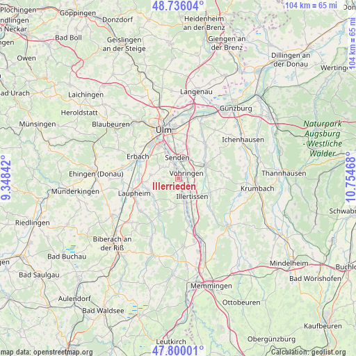
Illerrieden GPS coordinates[2]
48° 16' 12.612" North, 10° 3' 5.58" East
| Map corner | latitude | longitude |
|---|---|---|
| Upper-left | 48.73604°, | 9.34842° |
| Center: | 48.27017°, | 10.05155° |
| Lower-right: | 47.80001°, | 10.75468° |
| Map W x H: | 104.1×104.1 km | = 64.7×64.7mi |
| max Lat: | 55.01917° ⇑91.6% North |
| Illerrieden: | 48.27017° |
| min Lat: | ⇓8.4% South 47.40724° |
| min Long | Illerrieden | max Long |
| 5.92978° | 10.05155° | 14.98853° |
| W 51%⇐ | ⇒49% E |
Elevation
Elevation of Illerrieden is 500 m = 1640 ft, and this is 250.9 m = 823 ft above average elevation for this country.
| Max E: |
1256 m = 4121 ft | 11.4% |
| Illerrieden | 500 m 1640 ft | |
| Avg. | 249.1 m = 817 ft | |
Min E: |
-5 m = -16 ft | 88.6% |
See also: Germany elevation on elevation.city.
Geographical zone
Illerrieden is located in North temperate zone (between Tropic of Cancer and the Arctic Circle). Distance of this North polar circle is 2034 km =1263.9 mi to North.| Distance of | km | miles | from Illerrieden |
|---|---|---|---|
| North Pole | 4639.9 | 2883.1 | to North |
| Arctic Circle | 2034 | 1263.9 | to North |
| Tropic Cancer | 2761.2 | 1715.7 | to South |
| Equator | 5367.1 | 3335 | to South |


Nearby cities:
15 places around Illerrieden: (largest is in red/bold)
• Achstetten
11.5 km =7.1 mi,  263°
263°
• Bellenberg
3.2 km =2 mi,  116°
116°
• Buch
10.8 km =6.7 mi, 117°
• Burgrieden
9.7 km =6 mi,  244°
244°
• Dietenheim
6.8 km =4.2 mi,  167°
167°
• Hüttisheim
8.1 km =5 mi,  277°
277°
• Illertissen
6.5 km =4 mi,  143°
143°
• Schnürpflingen
4.3 km =2.7 mi,  273°
273°
• Schwendi
12.1 km =7.5 mi,  207°
207°
• Senden
6.1 km =3.8 mi,  355°
355°
• Staig
5.6 km =3.5 mi,  306°
306°
• Unterroth
12.1 km =7.5 mi,  133°
133°
• Vöhringen
2.5 km =1.6 mi,  68°
68°
• Wain
9.3 km =5.8 mi,  194°
194°
• Weißenhorn
8.9 km =5.5 mi,  64°
64°
Sources, notices
• [Note1] Compared only with cities in Germany existing in our database
• [Src1] Map data: © OpenStreetMap contributors (CC-BY-SA)
• [Src2] Other city data from geonames.org with taken over terms of usage.
• [Src3] Geographical zone / Annual Mean Temperature by Robert A. Rohde @ Wikipedia
