Usingen geodata
Usingen (Hesse) is a populated place; located in Germany in Europe/Berlin (GMT+2) time zone. With population of 13,511 people, there are 1185 cities with bigger population in this country. Compared to other cities in Germany, 55.8% of cities are located further ↑North; 70.7% of cities are located further →East and 61.5% of cities have lower elevation than Usingen. Note1
Administrative division(s):
- Level 1: Hesse
- Level 2: Regierungsbezirk Darmstadt
- Level 3: Hochtaunuskreis
- Level 4: Usingen


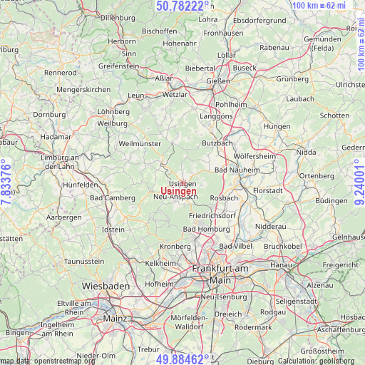
Usingen GPS coordinates[2]
50° 20' 7.944" North, 8° 32' 12.768" East
| Map corner | latitude | longitude |
|---|---|---|
| Upper-left | 50.78222°, | 7.83376° |
| Center: | 50.33554°, | 8.53688° |
| Lower-right: | 49.88462°, | 9.24001° |
| Map W x H: | 99.8×99.8 km | = 62×62mi |
| max Lat: | 55.01917° ⇑55.8% North |
| Usingen: | 50.33554° |
| min Lat: | ⇓44.2% South 47.40724° |
| min Long | Usingen | max Long |
| 5.92978° | 8.53688° | 14.98853° |
| W 29.3%⇐ | ⇒70.7% E |
Elevation
Elevation of Usingen is 299 m = 981 ft, and this is 49.9 m = 164 ft above average elevation for this country.
| Max E: |
1256 m = 4121 ft | 38.5% |
| Usingen | 299 m 981 ft | |
| Avg. | 249.1 m = 817 ft | |
Min E: |
-5 m = -16 ft | 61.5% |
See also: Germany elevation on elevation.city.
Geographical zone
Usingen is located in North temperate zone (between Tropic of Cancer and the Arctic Circle). Distance of this North polar circle is 1804.4 km =1121.2 mi to North.| Distance of | km | miles | from Usingen |
|---|---|---|---|
| North Pole | 4410.3 | 2740.4 | to North |
| Arctic Circle | 1804.4 | 1121.2 | to North |
| Tropic Cancer | 2990.9 | 1858.5 | to South |
| Equator | 5596.8 | 3477.7 | to South |


Nearby cities:
15 places around Usingen: (largest is in red/bold)
• Bad Homburg vor der Höhe
13.4 km =8.3 mi,  154°
154°
• Bad Nauheim
14.7 km =9.1 mi,  77°
77°
• Butzbach
14.5 km =9 mi,  41°
41°
• Friedberg
15.5 km =9.6 mi,  89°
89°
• Friedrichsdorf
12.2 km =7.6 mi,  141°
141°
• Glashütten
16.4 km =10.2 mi,  216°
216°
• Grävenwiesbach
8.3 km =5.2 mi,  316°
316°
• Neu-Anspach
3.4 km =2.1 mi,  231°
231°
• Ober-Mörlen
11.7 km =7.3 mi,  68°
68°
• Oberems
14.5 km =9 mi, 220°
• Oberursel
14.5 km =9 mi,  168°
168°
• Rosbach vor der Höhe
11.4 km =7.1 mi,  108°
108°
• Schmitten
9.8 km =6.1 mi, 218°
• Wehrheim
4.5 km =2.8 mi, 151°
• Weilmünster
15.6 km =9.7 mi,  313°
313°
Sources, notices
• [Note1] Compared only with cities in Germany existing in our database
• [Src1] Map data: © OpenStreetMap contributors (CC-BY-SA)
• [Src2] Other city data from geonames.org with taken over terms of usage.
• [Src3] Geographical zone / Annual Mean Temperature by Robert A. Rohde @ Wikipedia
