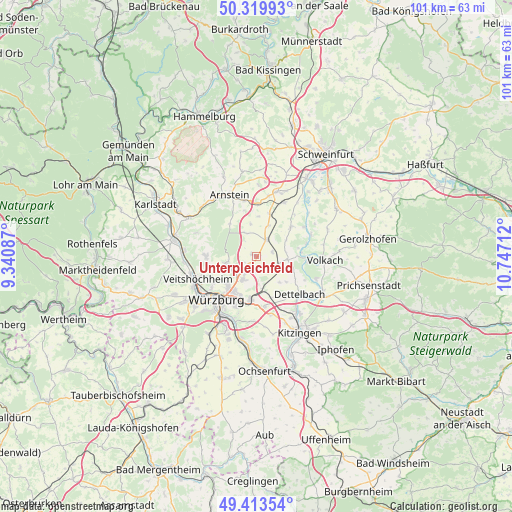
Unterpleichfeld geodata
Unterpleichfeld (Bavaria) is a seat of a fourth-order administrative division; located in Germany in Europe/Berlin (GMT+2) time zone. With population of 2,718 people, there are 4217 cities with bigger population in this country. Compared to other cities in Germany, 67.2% of cities are located further ↑North; 50.8% of cities are located further ←West and 56.3% of cities have lower elevation than Unterpleichfeld. Note1
Administrative division(s):
- Level 1: Bavaria
- Level 2: Regierungsbezirk Unterfranken
- Level 3: Landkreis Würzburg
- Level 4: Unterpleichfeld


Unterpleichfeld GPS coordinates[2]
49° 52' 7.896" North, 10° 2' 38.364" East
| Map corner | latitude | longitude |
|---|---|---|
| Upper-left | 50.31993°, | 9.34087° |
| Center: | 49.86886°, | 10.04399° |
| Lower-right: | 49.41354°, | 10.74712° |
| Map W x H: | 100.8×100.8 km | = 62.6×62.6mi |
| max Lat: | 55.01917° ⇑67.2% North |
| Unterpleichfeld: | 49.86886° |
| min Lat: | ⇓32.8% South 47.40724° |
| min Long | Unterpleichfeld | max Long |
| 5.92978° | 10.04399° | 14.98853° |
| W 50.8%⇐ | ⇒49.2% E |
Elevation
Elevation of Unterpleichfeld is 268 m = 879 ft, and this is 18.9 m = 62 ft above average elevation for this country.
| Max E: |
1256 m = 4121 ft | 43.7% |
| Unterpleichfeld | 268 m 879 ft | |
| Avg. | 249.1 m = 817 ft | |
Min E: |
-5 m = -16 ft | 56.3% |
See also: Germany elevation on elevation.city.
Geographical zone
Unterpleichfeld is located in North temperate zone (between Tropic of Cancer and the Arctic Circle). Distance of this North polar circle is 1856.3 km =1153.5 mi to North.| Distance of | km | miles | from Unterpleichfeld |
|---|---|---|---|
| North Pole | 4462.2 | 2772.7 | to North |
| Arctic Circle | 1856.3 | 1153.5 | to North |
| Tropic Cancer | 2939 | 1826.2 | to South |
| Equator | 5544.9 | 3445.4 | to South |


Nearby cities:
15 places around Unterpleichfeld: (largest is in red/bold)
• Bergtheim
3.8 km =2.4 mi,  25°
25°
• Dettelbach
11.4 km =7.1 mi,  130°
130°
• Estenfeld
5.2 km =3.2 mi,  211°
211°
• Gadheim
10.2 km =6.3 mi,  255°
255°
• Gerbrunn
11 km =6.8 mi,  199°
199°
• Güntersleben
10 km =6.2 mi,  270°
270°
• Kürnach
2.2 km =1.4 mi, 200°
• Nordheim
10.2 km =6.3 mi,  96°
96°
• Oberpleichfeld
3.2 km =2 mi,  73°
73°
• Prosselsheim
6 km =3.7 mi, 96°
• Rimpar
6.4 km =4 mi, 257°
• Rottendorf
8.6 km =5.3 mi,  188°
188°
• Schwanfeld
9 km =5.6 mi,  49°
49°
• Wipfeld
10.3 km =6.4 mi,  58°
58°
• Würzburg
10.7 km =6.6 mi,  218°
218°
Sources, notices
• [Note1] Compared only with cities in Germany existing in our database
• [Src1] Map data: © OpenStreetMap contributors (CC-BY-SA)
• [Src2] Other city data from geonames.org with taken over terms of usage.
• [Src3] Geographical zone / Annual Mean Temperature by Robert A. Rohde @ Wikipedia
