Schotten geodata
Schotten (Hesse) is a populated place; located in Germany in Europe/Berlin (GMT+2) time zone. With population of 11,566 people, there are 1421 cities with bigger population in this country. Compared to other cities in Germany, 52.7% of cities are located further ↑North; 63.6% of cities are located further →East and 58.7% of cities have lower elevation than Schotten. Note1
Administrative division(s):
- Level 1: Hesse
- Level 2: Regierungsbezirk Gießen
- Level 3: Vogelsbergkreis
- Level 4: Schotten


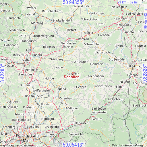
Schotten GPS coordinates[2]
50° 30' 12.456" North, 9° 7' 30.576" East
| Map corner | latitude | longitude |
|---|---|---|
| Upper-left | 50.94855°, | 8.42203° |
| Center: | 50.50346°, | 9.12516° |
| Lower-right: | 50.05413°, | 9.82828° |
| Map W x H: | 99.5×99.4 km | = 61.8×61.8mi |
| max Lat: | 55.01917° ⇑52.7% North |
| Schotten: | 50.50346° |
| min Lat: | ⇓47.3% South 47.40724° |
| min Long | Schotten | max Long |
| 5.92978° | 9.12516° | 14.98853° |
| W 36.4%⇐ | ⇒63.6% E |
Elevation
Elevation of Schotten is 282 m = 925 ft, and this is 32.9 m = 108 ft above average elevation for this country.
| Max E: |
1256 m = 4121 ft | 41.3% |
| Schotten | 282 m 925 ft | |
| Avg. | 249.1 m = 817 ft | |
Min E: |
-5 m = -16 ft | 58.7% |
See also: Germany elevation on elevation.city.
Geographical zone
Schotten is located in North temperate zone (between Tropic of Cancer and the Arctic Circle). Distance of this North polar circle is 1785.7 km =1109.6 mi to North.| Distance of | km | miles | from Schotten |
|---|---|---|---|
| North Pole | 4391.6 | 2728.8 | to North |
| Arctic Circle | 1785.7 | 1109.6 | to North |
| Tropic Cancer | 3009.5 | 1870 | to South |
| Equator | 5615.5 | 3489.3 | to South |


Nearby cities:
15 places around Schotten: (largest is in red/bold)
• Berstadt
20.2 km =12.6 mi,  244°
244°
• Gedern
10.2 km =6.3 mi,  149°
149°
• Grebenhain
15.2 km =9.4 mi,  95°
95°
• Grünberg
15.5 km =9.6 mi,  310°
310°
• Herbstein
16.9 km =10.5 mi,  67°
67°
• Hirzenhain
11.5 km =7.1 mi,  177°
177°
• Hungen
16.7 km =10.4 mi,  258°
258°
• Kefenrod
18.7 km =11.6 mi,  160°
160°
• Laubach
10.4 km =6.5 mi,  294°
294°
• Lautertal
14.3 km =8.9 mi,  51°
51°
• Nidda
13.1 km =8.1 mi,  219°
219°
• Ortenberg
17.1 km =10.6 mi,  196°
196°
• Ranstadt
19.1 km =11.9 mi,  211°
211°
• Steinheim
15.7 km =9.8 mi,  245°
245°
• Ulrichstein
9.3 km =5.8 mi,  30°
30°
Sources, notices
• [Note1] Compared only with cities in Germany existing in our database
• [Src1] Map data: © OpenStreetMap contributors (CC-BY-SA)
• [Src2] Other city data from geonames.org with taken over terms of usage.
• [Src3] Geographical zone / Annual Mean Temperature by Robert A. Rohde @ Wikipedia
