Theisbergstegen geodata
Theisbergstegen (Rheinland-Pfalz) is a populated place; located in Germany in Europe/Berlin (GMT+2) time zone. With population of 681 people, there are 8411 cities with bigger population in this country. Compared to other cities in Germany, 75.3% of cities are located further ↑North; 88% of cities are located further →East and 52.6% of cities have higher elevation than Theisbergstegen. Note1
Administrative division(s):
- Level 1: Rheinland-Pfalz
- Level 3: Landkreis Kusel
- Level 4: Theisbergstegen


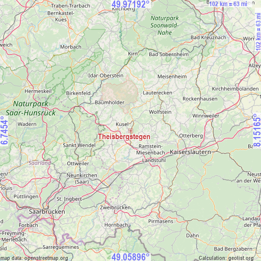
Theisbergstegen GPS coordinates[2]
49° 31' 3.252" North, 7° 26' 54.672" East
| Map corner | latitude | longitude |
|---|---|---|
| Upper-left | 49.97192°, | 6.7454° |
| Center: | 49.51757°, | 7.44852° |
| Lower-right: | 49.05896°, | 8.15165° |
| Map W x H: | 101.5×101.5 km | = 63.1×63.1mi |
| max Lat: | 55.01917° ⇑75.3% North |
| Theisbergstegen: | 49.51757° |
| min Lat: | ⇓24.7% South 47.40724° |
| min Long | Theisbergstegen | max Long |
| 5.92978° | 7.44852° | 14.98853° |
| W 12%⇐ | ⇒88% E |
Elevation
Elevation of Theisbergstegen is 207 m = 679 ft, and this is 42.1 m = 138 ft below average elevation for this country.
| Max E: |
1256 m = 4121 ft | 52.6% |
| Avg. | 249.1 m = 817 ft | |
| Theisbergstegen | 207 m = 679 ft | |
Min E: |
-5 m = -16 ft | 47.4% |
See also: Germany elevation on elevation.city.
Geographical zone
Theisbergstegen is located in North temperate zone (between Tropic of Cancer and the Arctic Circle). Distance of this North polar circle is 1895.3 km =1177.7 mi to North.| Distance of | km | miles | from Theisbergstegen |
|---|---|---|---|
| North Pole | 4501.2 | 2796.9 | to North |
| Arctic Circle | 1895.3 | 1177.7 | to North |
| Tropic Cancer | 2899.9 | 1801.9 | to South |
| Equator | 5505.8 | 3421.1 | to South |


Nearby cities:
15 places around Theisbergstegen: (largest is in red/bold)
• Altenglan
3.8 km =2.4 mi,  19°
19°
• Etschberg
1.1 km =0.7 mi,  264°
264°
• Föckelberg
3.1 km =1.9 mi,  55°
55°
• Glan-Münchweiler
5.1 km =3.2 mi,  185°
185°
• Haschbach am Remigiusberg
2.1 km =1.3 mi,  327°
327°
• Hüffler
5.1 km =3.2 mi,  247°
247°
• Kusel
3.9 km =2.4 mi,  305°
305°
• Matzenbach
2.4 km =1.5 mi,  146°
146°
• Neunkirchen am Potzberg
3.2 km =2 mi,  127°
127°
• Niederstaufenbach
5.2 km =3.2 mi,  70°
70°
• Oberstaufenbach
4.4 km =2.7 mi,  92°
92°
• Quirnbach
5.2 km =3.2 mi,  203°
203°
• Rammelsbach
2.7 km =1.7 mi,  352°
352°
• Rehweiler
3.6 km =2.2 mi, 187°
• Schellweiler
4.1 km =2.5 mi, 264°
Sources, notices
• [Note1] Compared only with cities in Germany existing in our database
• [Src1] Map data: © OpenStreetMap contributors (CC-BY-SA)
• [Src2] Other city data from geonames.org with taken over terms of usage.
• [Src3] Geographical zone / Annual Mean Temperature by Robert A. Rohde @ Wikipedia
