Rehweiler geodata
Rehweiler (Rheinland-Pfalz) is a seat of a fourth-order administrative division; located in Germany in Europe/Berlin (GMT+2) time zone. With population of 462 people, there are 9500 cities with bigger population in this country. Compared to other cities in Germany, 75.9% of cities are located further ↑North; 88% of cities are located further →East and 52.1% of cities have higher elevation than Rehweiler. Note1


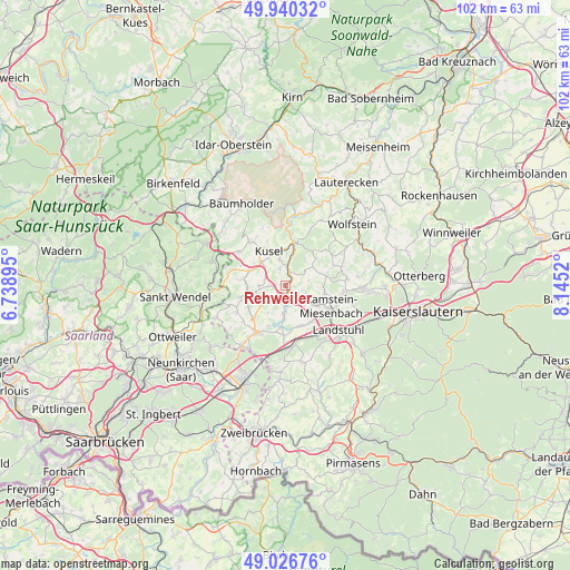
Rehweiler GPS coordinates[2]
49° 29' 8.412" North, 7° 26' 31.452" East
| Map corner | latitude | longitude |
|---|---|---|
| Upper-left | 49.94032°, | 6.73895° |
| Center: | 49.48567°, | 7.44207° |
| Lower-right: | 49.02676°, | 8.1452° |
| Map W x H: | 101.6×101.6 km | = 63.1×63.1mi |
| max Lat: | 55.01917° ⇑75.9% North |
| Rehweiler: | 49.48567° |
| min Lat: | ⇓24.1% South 47.40724° |
| min Long | Rehweiler | max Long |
| 5.92978° | 7.44207° | 14.98853° |
| W 12%⇐ | ⇒88% E |
Elevation
Elevation of Rehweiler is 211 m = 692 ft, and this is 38.1 m = 125 ft below average elevation for this country.
| Max E: |
1256 m = 4121 ft | 52.1% |
| Avg. | 249.1 m = 817 ft | |
| Rehweiler | 211 m = 692 ft | |
Min E: |
-5 m = -16 ft | 47.9% |
See also: Germany elevation on elevation.city.
Geographical zone
Rehweiler is located in North temperate zone (between Tropic of Cancer and the Arctic Circle). Distance of this North polar circle is 1898.9 km =1179.9 mi to North.| Distance of | km | miles | from Rehweiler |
|---|---|---|---|
| North Pole | 4504.8 | 2799.2 | to North |
| Arctic Circle | 1898.9 | 1179.9 | to North |
| Tropic Cancer | 2896.4 | 1799.7 | to South |
| Equator | 5502.3 | 3419 | to South |


Nearby cities:
15 places around Rehweiler: (largest is in red/bold)
• Etschberg
3.5 km =2.2 mi,  349°
349°
• Föckelberg
6.1 km =3.8 mi,  29°
29°
• Glan-Münchweiler
1.5 km =0.9 mi,  180°
180°
• Haschbach am Remigiusberg
5.3 km =3.3 mi, 353°
• Hüffler
4.5 km =2.8 mi,  290°
290°
• Matzenbach
2.4 km =1.5 mi,  48°
48°
• Nanzdietschweiler
4 km =2.5 mi,  171°
171°
• Neunkirchen am Potzberg
3.4 km =2.1 mi,  61°
61°
• Niedermohr
3.6 km =2.2 mi,  146°
146°
• Oberstaufenbach
5.9 km =3.7 mi, 55°
• Quirnbach
2 km =1.2 mi,  232°
232°
• Rammelsbach
6.2 km =3.9 mi,  1°
1°
• Schellweiler
4.8 km =3 mi,  310°
310°
• Theisbergstegen
3.6 km =2.2 mi,  7°
7°
• Wahnwegen
4.7 km =2.9 mi,  268°
268°
Sources, notices
• [Note1] Compared only with cities in Germany existing in our database
• [Src1] Map data: © OpenStreetMap contributors (CC-BY-SA)
• [Src2] Other city data from geonames.org with taken over terms of usage.
• [Src3] Geographical zone / Annual Mean Temperature by Robert A. Rohde @ Wikipedia
