Teublitz geodata
Teublitz (Bavaria) is a populated place; located in Germany in Europe/Berlin (GMT+2) time zone. With population of 7,405 people, there are 2092 cities with bigger population in this country. Compared to other cities in Germany, 80% of cities are located further ↑North; 83% of cities are located further ←West and 69.5% of cities have lower elevation than Teublitz. Note1
Administrative division(s):
- Level 1: Bavaria
- Level 2: Upper Palatinate
- Level 3: Landkreis Schwandorf
- Level 4: Teublitz


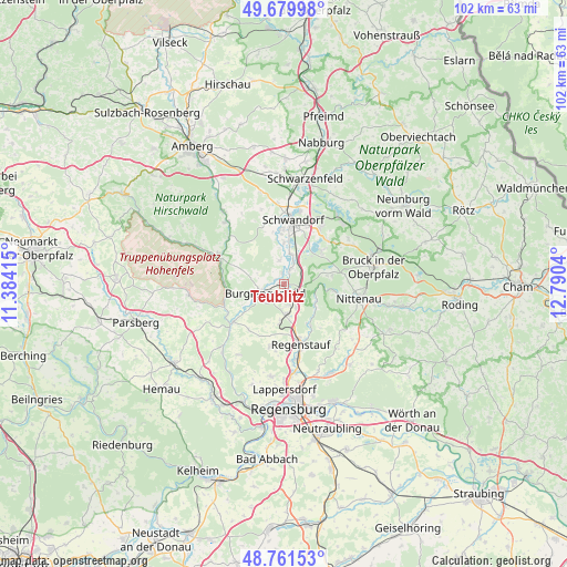
Teublitz GPS coordinates[2]
49° 13' 22.404" North, 12° 5' 14.172" East
| Map corner | latitude | longitude |
|---|---|---|
| Upper-left | 49.67998°, | 11.38415° |
| Center: | 49.22289°, | 12.08727° |
| Lower-right: | 48.76153°, | 12.7904° |
| Map W x H: | 102.1×102.1 km | = 63.4×63.4mi |
| max Lat: | 55.01917° ⇑80% North |
| Teublitz: | 49.22289° |
| min Lat: | ⇓20% South 47.40724° |
| min Long | Teublitz | max Long |
| 5.92978° | 12.08727° | 14.98853° |
| W 83%⇐ | ⇒17% E |
Elevation
Elevation of Teublitz is 355 m = 1165 ft, and this is 105.9 m = 347 ft above average elevation for this country.
| Max E: |
1256 m = 4121 ft | 30.5% |
| Teublitz | 355 m 1165 ft | |
| Avg. | 249.1 m = 817 ft | |
Min E: |
-5 m = -16 ft | 69.5% |
See also: Germany elevation on elevation.city.
Geographical zone
Teublitz is located in North temperate zone (between Tropic of Cancer and the Arctic Circle). Distance of this North polar circle is 1928.1 km =1198.1 mi to North.| Distance of | km | miles | from Teublitz |
|---|---|---|---|
| North Pole | 4534 | 2817.3 | to North |
| Arctic Circle | 1928.1 | 1198.1 | to North |
| Tropic Cancer | 2867.2 | 1781.6 | to South |
| Equator | 5473.1 | 3400.8 | to South |


Nearby cities:
15 places around Teublitz: (largest is in red/bold)
• Bruck in der Oberpfalz
16.2 km =10.1 mi,  79°
79°
• Brunn
7.7 km =4.8 mi, 78°
• Burglengenfeld
3.8 km =2.4 mi,  235°
235°
• Holzheim bei Oder
7.5 km =4.7 mi,  49°
49°
• Kallmünz
11.5 km =7.1 mi,  233°
233°
• Maxhütte-Haidhof
2.6 km =1.6 mi,  171°
171°
• Nittenau
13.5 km =8.4 mi,  103°
103°
• Regenstauf
11.8 km =7.3 mi,  164°
164°
• Rieden
15.4 km =9.6 mi,  316°
316°
• Schmidmühlen
12.9 km =8 mi,  293°
293°
• Schwandorf in Bayern
11.5 km =7.1 mi,  8°
8°
• Steinberg
9.7 km =6 mi, 46°
• Wackersdorf
12.5 km =7.8 mi,  33°
33°
• Wolfsegg
15.1 km =9.4 mi,  211°
211°
• Zeitlarn
16.2 km =10.1 mi, 173°
Sources, notices
• [Note1] Compared only with cities in Germany existing in our database
• [Src1] Map data: © OpenStreetMap contributors (CC-BY-SA)
• [Src2] Other city data from geonames.org with taken over terms of usage.
• [Src3] Geographical zone / Annual Mean Temperature by Robert A. Rohde @ Wikipedia
