Liebenwalde geodata
Liebenwalde (Brandenburg) is a populated place; located in Germany in Europe/Berlin (GMT+2) time zone. With population of 4,649 people, there are 2964 cities with bigger population in this country. Compared to other cities in Germany, 80.9% of cities are located further ↓South; 95% of cities are located further ←West and 81.4% of cities have higher elevation than Liebenwalde. Note1


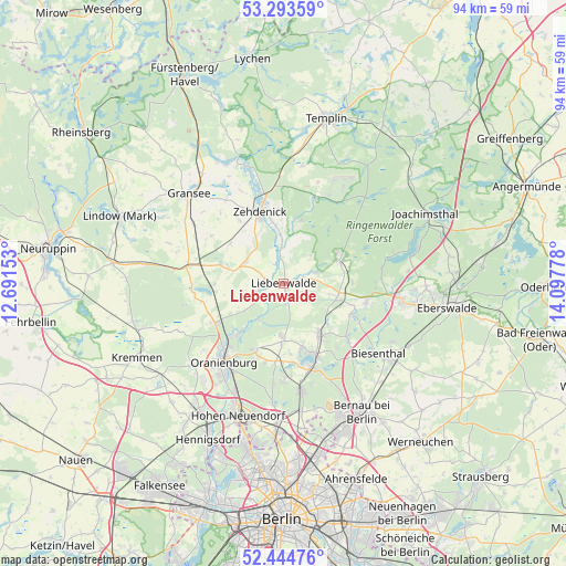
Liebenwalde GPS coordinates[2]
52° 52' 16.5" North, 13° 23' 40.74" East
| Map corner | latitude | longitude |
|---|---|---|
| Upper-left | 53.29359°, | 12.69153° |
| Center: | 52.87125°, | 13.39465° |
| Lower-right: | 52.44476°, | 14.09778° |
| Map W x H: | 94.4×94.4 km | = 58.7×58.7mi |
| max Lat: | 55.01917° ⇑19.1% North |
| Liebenwalde: | 52.87125° |
| min Lat: | ⇓80.9% South 47.40724° |
| min Long | Liebenwalde | max Long |
| 5.92978° | 13.39465° | 14.98853° |
| W 95%⇐ | ⇒5% E |
Elevation
Elevation of Liebenwalde is 43 m = 141 ft, and this is 206.1 m = 676 ft below average elevation for this country.
| Max E: |
1256 m = 4121 ft | 81.4% |
| Avg. | 249.1 m = 817 ft | |
| Liebenwalde | 43 m = 141 ft | |
Min E: |
-5 m = -16 ft | 18.6% |
See also: Germany elevation on elevation.city.
Geographical zone
Liebenwalde is located in North temperate zone (between Tropic of Cancer and the Arctic Circle). Distance of this North polar circle is 1522.4 km =946 mi to North.| Distance of | km | miles | from Liebenwalde |
|---|---|---|---|
| North Pole | 4128.3 | 2565.2 | to North |
| Arctic Circle | 1522.4 | 946 | to North |
| Tropic Cancer | 3272.8 | 2033.6 | to South |
| Equator | 5878.7 | 3652.9 | to South |


Nearby cities:
15 places around Liebenwalde: (largest is in red/bold)
• Bernau bei Berlin
24.9 km =15.5 mi,  148°
148°
• Biesenthal
20.4 km =12.7 mi,  124°
124°
• Birkenwerder
22.2 km =13.8 mi,  199°
199°
• Gransee
21.9 km =13.6 mi,  313°
313°
• Hohen Neuendorf
23.1 km =14.4 mi, 199°
• Leegebruch
21.3 km =13.2 mi,  219°
219°
• Marienwerder
14.1 km =8.8 mi,  103°
103°
• Melchow
23.5 km =14.6 mi, 116°
• Oranienburg
16.4 km =10.2 mi, 218°
• Rüdnitz
22.8 km =14.2 mi,  137°
137°
• Schönermark
23.8 km =14.8 mi, 309°
• Sonnenberg
26.3 km =16.3 mi, 308°
• Velten
24.8 km =15.4 mi, 216°
• Wandlitz
15 km =9.3 mi,  163°
163°
• Zehdenick
12.7 km =7.9 mi,  340°
340°
Sources, notices
• [Note1] Compared only with cities in Germany existing in our database
• [Src1] Map data: © OpenStreetMap contributors (CC-BY-SA)
• [Src2] Other city data from geonames.org with taken over terms of usage.
• [Src3] Geographical zone / Annual Mean Temperature by Robert A. Rohde @ Wikipedia
