Dornstedt geodata
Dornstedt (Saxony-Anhalt) is a populated place; located in Germany in Europe/Berlin (GMT+2) time zone. With population of 785 people, there are 7961 cities with bigger population in this country. Compared to other cities in Germany, 64.9% of cities are located further ↓South; 77.9% of cities are located further ←West and 61.3% of cities have higher elevation than Dornstedt. Note1


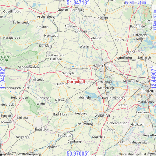
Dornstedt GPS coordinates[2]
51° 24' 38.592" North, 11° 44' 45.384" East
| Map corner | latitude | longitude |
|---|---|---|
| Upper-left | 51.84718°, | 11.04282° |
| Center: | 51.41072°, | 11.74594° |
| Lower-right: | 50.97005°, | 12.44907° |
| Map W x H: | 97.5×97.5 km | = 60.6×60.6mi |
| max Lat: | 55.01917° ⇑35.1% North |
| Dornstedt: | 51.41072° |
| min Lat: | ⇓64.9% South 47.40724° |
| min Long | Dornstedt | max Long |
| 5.92978° | 11.74594° | 14.98853° |
| W 77.9%⇐ | ⇒22.1% E |
Elevation
Elevation of Dornstedt is 144 m = 472 ft, and this is 105.1 m = 345 ft below average elevation for this country.
| Max E: |
1256 m = 4121 ft | 61.3% |
| Avg. | 249.1 m = 817 ft | |
| Dornstedt | 144 m = 472 ft | |
Min E: |
-5 m = -16 ft | 38.7% |
See also: Germany elevation on elevation.city.
Geographical zone
Dornstedt is located in North temperate zone (between Tropic of Cancer and the Arctic Circle). Distance of this North polar circle is 1684.8 km =1046.9 mi to North.| Distance of | km | miles | from Dornstedt |
|---|---|---|---|
| North Pole | 4290.7 | 2666.1 | to North |
| Arctic Circle | 1684.8 | 1046.9 | to North |
| Tropic Cancer | 3110.4 | 1932.7 | to South |
| Equator | 5716.3 | 3551.9 | to South |


Nearby cities:
15 places around Dornstedt: (largest is in red/bold)
• Alberstedt
9.3 km =5.8 mi,  296°
296°
• Amsdorf
6.1 km =3.8 mi,  347°
347°
• Bad Lauchstädt
9 km =5.6 mi,  107°
107°
• Esperstedt
4.9 km =3 mi,  287°
287°
• Klobikau
9.1 km =5.7 mi,  138°
138°
• Langenbogen
8.3 km =5.2 mi,  15°
15°
• Langeneichstädt
7.3 km =4.5 mi,  181°
181°
• Obhausen
6.8 km =4.2 mi,  251°
251°
• Röblingen am See
7 km =4.3 mi,  320°
320°
• Schafstädt
3.8 km =2.4 mi,  150°
150°
• Schraplau
6.2 km =3.9 mi, 298°
• Stedten
5.1 km =3.2 mi,  314°
314°
• Steuden
1.7 km =1.1 mi,  57°
57°
• Teutschenthal
5.8 km =3.6 mi,  40°
40°
• Wansleben
5.5 km =3.4 mi,  3°
3°
Sources, notices
• [Note1] Compared only with cities in Germany existing in our database
• [Src1] Map data: © OpenStreetMap contributors (CC-BY-SA)
• [Src2] Other city data from geonames.org with taken over terms of usage.
• [Src3] Geographical zone / Annual Mean Temperature by Robert A. Rohde @ Wikipedia
