Eschenlohe geodata
Eschenlohe (Bavaria) is a populated place; located in Germany in Europe/Berlin (GMT+2) time zone. With population of 1,647 people, there are 5610 cities with bigger population in this country. Compared to other cities in Germany, 95.3% of cities are located further ↑North; 82.2% of cities are located further ←West and 92.1% of cities have lower elevation than Eschenlohe. Note1
Administrative division(s):
- Level 1: Bavaria
- Level 2: Upper Bavaria
- Level 3: Landkreis Ebersberg
- Level 4: Frauenneuharting


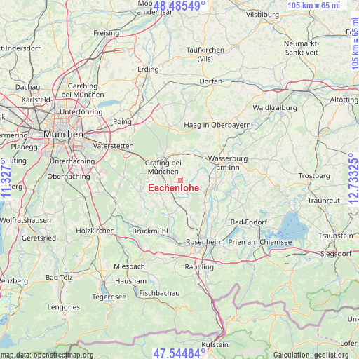
Eschenlohe GPS coordinates[2]
48° 1' 2.316" North, 12° 1' 48.432" East
| Map corner | latitude | longitude |
|---|---|---|
| Upper-left | 48.48549°, | 11.327° |
| Center: | 48.01731°, | 12.03012° |
| Lower-right: | 47.54484°, | 12.73325° |
| Map W x H: | 104.6×104.6 km | = 65×65mi |
| max Lat: | 55.01917° ⇑95.3% North |
| Eschenlohe: | 48.01731° |
| min Lat: | ⇓4.7% South 47.40724° |
| min Long | Eschenlohe | max Long |
| 5.92978° | 12.03012° | 14.98853° |
| W 82.2%⇐ | ⇒17.8% E |
Elevation
Elevation of Eschenlohe is 543 m = 1781 ft, and this is 293.9 m = 964 ft above average elevation for this country.
| Max E: |
1256 m = 4121 ft | 7.9% |
| Eschenlohe | 543 m 1781 ft | |
| Avg. | 249.1 m = 817 ft | |
Min E: |
-5 m = -16 ft | 92.1% |
See also: Germany elevation on elevation.city.
Geographical zone
Eschenlohe is located in North temperate zone (between Tropic of Cancer and the Arctic Circle). Distance of this North polar circle is 2062.1 km =1281.3 mi to North.| Distance of | km | miles | from Eschenlohe |
|---|---|---|---|
| North Pole | 4668 | 2900.6 | to North |
| Arctic Circle | 2062.1 | 1281.3 | to North |
| Tropic Cancer | 2733.1 | 1698.3 | to South |
| Equator | 5339 | 3317.5 | to South |


Nearby cities:
15 places around Eschenlohe: (largest is in red/bold)
• Aßling
3.2 km =2 mi,  213°
213°
• Breitbrunn
9.7 km =6 mi,  72°
72°
• Bruck
9.1 km =5.7 mi,  272°
272°
• Ebersberg
8 km =5 mi,  326°
326°
• Edling
10.9 km =6.8 mi, 66°
• Emmering
2.9 km =1.8 mi,  138°
138°
• Fraueneuharting
2.7 km =1.7 mi,  28°
28°
• Grafing bei München
5.6 km =3.5 mi,  304°
304°
• Griesstätt
11.2 km =7 mi,  103°
103°
• Hohenthann
7 km =4.3 mi,  230°
230°
• Pfaffing
7.2 km =4.5 mi,  54°
54°
• Ramerberg
8.6 km =5.3 mi,  89°
89°
• Rott
11.6 km =7.2 mi,  158°
158°
• Steinhöring
7.7 km =4.8 mi,  0°
0°
• Tuntenhausen
9.2 km =5.7 mi,  186°
186°
Sources, notices
• [Note1] Compared only with cities in Germany existing in our database
• [Src1] Map data: © OpenStreetMap contributors (CC-BY-SA)
• [Src2] Other city data from geonames.org with taken over terms of usage.
• [Src3] Geographical zone / Annual Mean Temperature by Robert A. Rohde @ Wikipedia
