Ebersberg geodata
Ebersberg (Bavaria) is a seat of a third-order administrative division; located in Germany in Europe/Berlin (GMT+2) time zone. With population of 11,041 people, there are 1498 cities with bigger population in this country. Compared to other cities in Germany, 94.4% of cities are located further ↑North; 81.4% of cities are located further ←West and 93.3% of cities have lower elevation than Ebersberg. Note1
Administrative division(s):
- Level 1: Bavaria
- Level 2: Upper Bavaria
- Level 3: Landkreis Ebersberg
- Level 4: Ebersberg


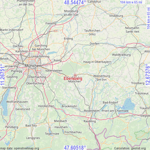
Ebersberg GPS coordinates[2]
48° 4' 37.56" North, 11° 58' 14.268" East
| Map corner | latitude | longitude |
|---|---|---|
| Upper-left | 48.54474°, | 11.26751° |
| Center: | 48.0771°, | 11.97063° |
| Lower-right: | 47.60518°, | 12.67376° |
| Map W x H: | 104.5×104.5 km | = 64.9×64.9mi |
| max Lat: | 55.01917° ⇑94.4% North |
| Ebersberg: | 48.0771° |
| min Lat: | ⇓5.6% South 47.40724° |
| min Long | Ebersberg | max Long |
| 5.92978° | 11.97063° | 14.98853° |
| W 81.4%⇐ | ⇒18.6% E |
Elevation
Elevation of Ebersberg is 563 m = 1847 ft, and this is 313.9 m = 1030 ft above average elevation for this country.
| Max E: |
1256 m = 4121 ft | 6.7% |
| Ebersberg | 563 m 1847 ft | |
| Avg. | 249.1 m = 817 ft | |
Min E: |
-5 m = -16 ft | 93.3% |
See also: Germany elevation on elevation.city.
Geographical zone
Ebersberg is located in North temperate zone (between Tropic of Cancer and the Arctic Circle). Distance of this North polar circle is 2055.5 km =1277.2 mi to North.| Distance of | km | miles | from Ebersberg |
|---|---|---|---|
| North Pole | 4661.4 | 2896.5 | to North |
| Arctic Circle | 2055.5 | 1277.2 | to North |
| Tropic Cancer | 2739.8 | 1702.4 | to South |
| Equator | 5345.7 | 3321.7 | to South |


Nearby cities:
15 places around Ebersberg: (largest is in red/bold)
• Albaching
11 km =6.8 mi,  70°
70°
• Aßling
9.7 km =6 mi,  164°
164°
• Bruck
7.8 km =4.8 mi,  216°
216°
• Emmering
10.9 km =6.8 mi,  144°
144°
• Eschenlohe
8 km =5 mi,  146°
146°
• Forstinning
11.1 km =6.9 mi,  337°
337°
• Fraueneuharting
7.1 km =4.4 mi,  126°
126°
• Grafing bei München
3.5 km =2.2 mi,  183°
183°
• Hohenlinden
9 km =5.6 mi,  11°
11°
• Hohenthann
11.1 km =6.9 mi,  185°
185°
• Kirchseeon
6.1 km =3.8 mi,  264°
264°
• Moosach
8.7 km =5.4 mi,  234°
234°
• Pfaffing
10.6 km =6.6 mi,  103°
103°
• Steinhöring
4.6 km =2.9 mi,  76°
76°
• Zorneding
10.9 km =6.8 mi,  274°
274°
Sources, notices
• [Note1] Compared only with cities in Germany existing in our database
• [Src1] Map data: © OpenStreetMap contributors (CC-BY-SA)
• [Src2] Other city data from geonames.org with taken over terms of usage.
• [Src3] Geographical zone / Annual Mean Temperature by Robert A. Rohde @ Wikipedia
