Emmering geodata
Emmering (Bavaria) is a seat of a fourth-order administrative division; located in Germany in Europe/Berlin (GMT+2) time zone. With population of 1,427 people, there are 6026 cities with bigger population in this country. Compared to other cities in Germany, 95.6% of cities are located further ↑North; 82.6% of cities are located further ←West and 86.8% of cities have lower elevation than Emmering. Note1
Administrative division(s):
- Level 1: Bavaria
- Level 2: Upper Bavaria
- Level 3: Landkreis Ebersberg
- Level 4: Emmering


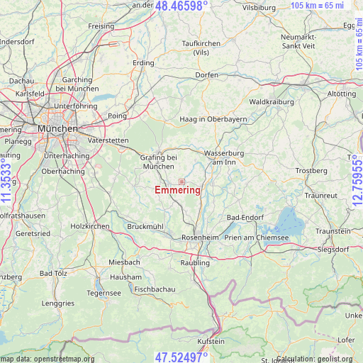
Emmering GPS coordinates[2]
47° 59' 51.432" North, 12° 3' 23.112" East
| Map corner | latitude | longitude |
|---|---|---|
| Upper-left | 48.46598°, | 11.3533° |
| Center: | 47.99762°, | 12.05642° |
| Lower-right: | 47.52497°, | 12.75955° |
| Map W x H: | 104.6×104.6 km | = 65×65mi |
| max Lat: | 55.01917° ⇑95.6% North |
| Emmering: | 47.99762° |
| min Lat: | ⇓4.4% South 47.40724° |
| min Long | Emmering | max Long |
| 5.92978° | 12.05642° | 14.98853° |
| W 82.6%⇐ | ⇒17.4% E |
Elevation
Elevation of Emmering is 484 m = 1588 ft, and this is 234.9 m = 771 ft above average elevation for this country.
| Max E: |
1256 m = 4121 ft | 13.2% |
| Emmering | 484 m 1588 ft | |
| Avg. | 249.1 m = 817 ft | |
Min E: |
-5 m = -16 ft | 86.8% |
See also: Germany elevation on elevation.city.
Geographical zone
Emmering is located in North temperate zone (between Tropic of Cancer and the Arctic Circle). Distance of this North polar circle is 2064.3 km =1282.7 mi to North.| Distance of | km | miles | from Emmering |
|---|---|---|---|
| North Pole | 4670.2 | 2901.9 | to North |
| Arctic Circle | 2064.3 | 1282.7 | to North |
| Tropic Cancer | 2730.9 | 1696.9 | to South |
| Equator | 5336.8 | 3316.1 | to South |


Nearby cities:
15 places around Emmering: (largest is in red/bold)
• Aßling
3.8 km =2.4 mi,  262°
262°
• Breitbrunn
8.9 km =5.5 mi,  55°
55°
• Edling
10.4 km =6.5 mi,  51°
51°
• Eschenlohe
2.9 km =1.8 mi,  318°
318°
• Fraueneuharting
4.6 km =2.9 mi,  352°
352°
• Grafing bei München
8.5 km =5.3 mi,  309°
309°
• Griesstätt
9 km =5.6 mi,  92°
92°
• Hohenthann
7.7 km =4.8 mi,  253°
253°
• Pfaffing
7.4 km =4.6 mi,  31°
31°
• Ramerberg
7 km =4.3 mi,  70°
70°
• Rott
8.9 km =5.5 mi,  164°
164°
• Schechen
9.1 km =5.7 mi,  146°
146°
• Steinhöring
10.1 km =6.3 mi, 349°
• Tuntenhausen
7.6 km =4.7 mi,  203°
203°
• Vogtareuth
10.9 km =6.8 mi,  121°
121°
Sources, notices
• [Note1] Compared only with cities in Germany existing in our database
• [Src1] Map data: © OpenStreetMap contributors (CC-BY-SA)
• [Src2] Other city data from geonames.org with taken over terms of usage.
• [Src3] Geographical zone / Annual Mean Temperature by Robert A. Rohde @ Wikipedia
