Immelborn geodata
Immelborn (Thuringia) is a populated place; located in Germany in Europe/Berlin (GMT+2) time zone. With population of 1,860 people, there are 5260 cities with bigger population in this country. Compared to other cities in Germany, 54% of cities are located further ↓South; 54.9% of cities are located further ←West and 54.1% of cities have lower elevation than Immelborn. Note1


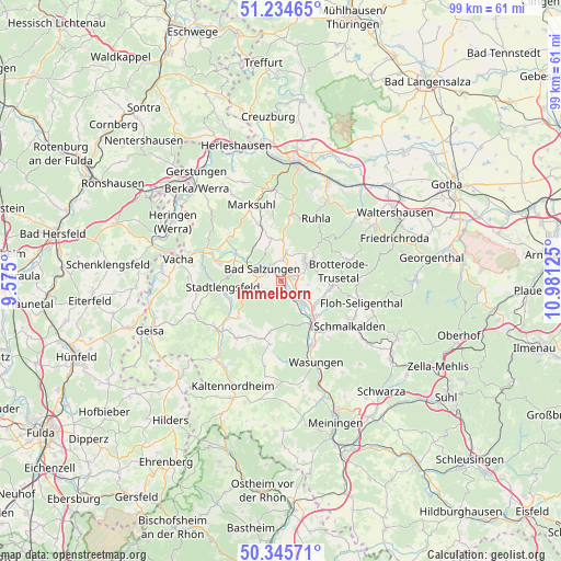
Immelborn GPS coordinates[2]
50° 47' 32.244" North, 10° 16' 41.232" East
| Map corner | latitude | longitude |
|---|---|---|
| Upper-left | 51.23465°, | 9.575° |
| Center: | 50.79229°, | 10.27812° |
| Lower-right: | 50.34571°, | 10.98125° |
| Map W x H: | 98.8×98.8 km | = 61.4×61.4mi |
| max Lat: | 55.01917° ⇑46% North |
| Immelborn: | 50.79229° |
| min Lat: | ⇓54% South 47.40724° |
| min Long | Immelborn | max Long |
| 5.92978° | 10.27812° | 14.98853° |
| W 54.9%⇐ | ⇒45.1% E |
Elevation
Elevation of Immelborn is 252 m = 827 ft, and this is 2.9 m = 10 ft above average elevation for this country.
| Max E: |
1256 m = 4121 ft | 45.9% |
| Immelborn | 252 m 827 ft | |
| Avg. | 249.1 m = 817 ft | |
Min E: |
-5 m = -16 ft | 54.1% |
See also: Germany elevation on elevation.city.
Geographical zone
Immelborn is located in North temperate zone (between Tropic of Cancer and the Arctic Circle). Distance of this North polar circle is 1753.6 km =1089.6 mi to North.| Distance of | km | miles | from Immelborn |
|---|---|---|---|
| North Pole | 4359.5 | 2708.9 | to North |
| Arctic Circle | 1753.6 | 1089.6 | to North |
| Tropic Cancer | 3041.7 | 1890 | to South |
| Equator | 5647.6 | 3509.3 | to South |


Nearby cities:
15 places around Immelborn: (largest is in red/bold)
• Bad Liebenstein
5.8 km =3.6 mi,  63°
63°
• Bad Salzungen
3.8 km =2.4 mi,  308°
308°
• Barchfeld
1.8 km =1.1 mi, 60°
• Breitungen
4.7 km =2.9 mi,  132°
132°
• Ettenhausen
10.3 km =6.4 mi,  341°
341°
• Fambach
9 km =5.6 mi,  136°
136°
• Leimbach
6.1 km =3.8 mi,  296°
296°
• Rosa
9.1 km =5.7 mi,  192°
192°
• Schweina
5.6 km =3.5 mi,  49°
49°
• Steinbach
7.6 km =4.7 mi, 52°
• Tiefenort
9.5 km =5.9 mi, 303°
• Trusetal
9.8 km =6.1 mi,  95°
95°
• Urnshausen
9.7 km =6 mi,  229°
229°
• Weilar
9.4 km =5.8 mi,  252°
252°
• Wernshausen
9.2 km =5.7 mi,  146°
146°
Sources, notices
• [Note1] Compared only with cities in Germany existing in our database
• [Src1] Map data: © OpenStreetMap contributors (CC-BY-SA)
• [Src2] Other city data from geonames.org with taken over terms of usage.
• [Src3] Geographical zone / Annual Mean Temperature by Robert A. Rohde @ Wikipedia
