Wangerooge geodata
Wangerooge (Lower Saxony) is a populated place; located in Germany in Europe/Berlin (GMT+2) time zone. With population of 1,081 people, there are 6907 cities with bigger population in this country. Compared to other cities in Germany, 89.9% of cities are located further ↓South; 79% of cities are located further →East and 96.2% of cities have higher elevation than Wangerooge. Note1
Administrative division(s):
- Level 1: Lower Saxony
- Level 3: Landkreis Friesland
- Level 4: Wangerooge, Nordseebad


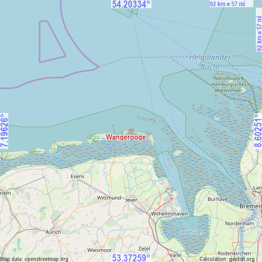
Wangerooge GPS coordinates[2]
53° 47' 24.072" North, 7° 53' 57.768" East
| Map corner | latitude | longitude |
|---|---|---|
| Upper-left | 54.20334°, | 7.19626° |
| Center: | 53.79002°, | 7.89938° |
| Lower-right: | 53.37259°, | 8.60251° |
| Map W x H: | 92.4×92.4 km | = 57.4×57.4mi |
| max Lat: | 55.01917° ⇑10.1% North |
| Wangerooge: | 53.79002° |
| min Lat: | ⇓89.9% South 47.40724° |
| min Long | Wangerooge | max Long |
| 5.92978° | 7.89938° | 14.98853° |
| W 21%⇐ | ⇒79% E |
Elevation
Elevation of Wangerooge is 6 m = 20 ft, and this is 243.1 m = 798 ft below average elevation for this country.
| Max E: |
1256 m = 4121 ft | 96.2% |
| Avg. | 249.1 m = 817 ft | |
| Wangerooge | 6 m = 20 ft | |
Min E: |
-5 m = -16 ft | 3.8% |
See also: Germany elevation on elevation.city.
Geographical zone
Wangerooge is located in North temperate zone (between Tropic of Cancer and the Arctic Circle). Distance of this North polar circle is 1420.3 km =882.5 mi to North.| Distance of | km | miles | from Wangerooge |
|---|---|---|---|
| North Pole | 4026.2 | 2501.8 | to North |
| Arctic Circle | 1420.3 | 882.5 | to North |
| Tropic Cancer | 3375 | 2097.1 | to South |
| Equator | 5980.9 | 3716.4 | to South |


Nearby cities:
15 places around Wangerooge: (largest is in red/bold)
• Bensersiel
24.8 km =15.4 mi,  238°
238°
• Carolinensiel
12.8 km =8 mi,  210°
210°
• Dunum
26.8 km =16.7 mi,  217°
217°
• Esens
24.6 km =15.3 mi,  230°
230°
• Fedderwarden
27.1 km =16.8 mi,  159°
159°
• Jever
24.1 km =15 mi,  180°
180°
• Langeoog
27.7 km =17.2 mi,  260°
260°
• Moorweg
27.1 km =16.8 mi, 230°
• Neuharlingersiel
16.3 km =10.1 mi, 232°
• Schillig
12.5 km =7.8 mi,  140°
140°
• Sillenstede
24.6 km =15.3 mi,  166°
166°
• Spiekeroog
13.6 km =8.5 mi, 260°
• Stedesdorf
23.2 km =14.4 mi, 221°
• Werdum
18.9 km =11.7 mi, 218°
• Wittmund
25 km =15.5 mi,  198°
198°
Sources, notices
• [Note1] Compared only with cities in Germany existing in our database
• [Src1] Map data: © OpenStreetMap contributors (CC-BY-SA)
• [Src2] Other city data from geonames.org with taken over terms of usage.
• [Src3] Geographical zone / Annual Mean Temperature by Robert A. Rohde @ Wikipedia
