Mühlheim am Main geodata
Mühlheim am Main (Hesse) is a populated place; located in Germany in Europe/Berlin (GMT+2) time zone. With population of 26,485 people, there are 544 cities with bigger population in this country. Compared to other cities in Germany, 61% of cities are located further ↑North; 67.5% of cities are located further →East and 67.8% of cities have higher elevation than Mühlheim am Main. Note1
Administrative division(s):
- Level 1: Hesse
- Level 2: Regierungsbezirk Darmstadt
- Level 3: Landkreis Offenbach
- Level 4: Mühlheim am Main


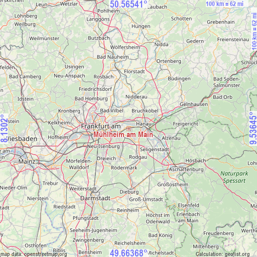
Mühlheim am Main GPS coordinates[2]
50° 7' 0.012" North, 8° 49' 59.988" East
| Map corner | latitude | longitude |
|---|---|---|
| Upper-left | 50.56541°, | 8.1302° |
| Center: | 50.11667°, | 8.83333° |
| Lower-right: | 49.66368°, | 9.53645° |
| Map W x H: | 100.3×100.3 km | = 62.3×62.3mi |
| max Lat: | 55.01917° ⇑61% North |
| Mühlheim am Main: | 50.11667° |
| min Lat: | ⇓39% South 47.40724° |
| min Long | Mühlheim am Ma | max Long |
| 5.92978° | 8.83333° | 14.98853° |
| W 32.5%⇐ | ⇒67.5% E |
Elevation
Elevation of Mühlheim am Main is 103 m = 338 ft, and this is 146.1 m = 479 ft below average elevation for this country.
| Max E: |
1256 m = 4121 ft | 67.8% |
| Avg. | 249.1 m = 817 ft | |
| Mühlheim am Main | 103 m = 338 ft | |
Min E: |
-5 m = -16 ft | 32.2% |
See also: Germany elevation on elevation.city.
Geographical zone
Mühlheim am Main is located in North temperate zone (between Tropic of Cancer and the Arctic Circle). Distance of this North polar circle is 1828.7 km =1136.3 mi to North.| Distance of | km | miles | from Mühlheim am Main |
|---|---|---|---|
| North Pole | 4434.6 | 2755.5 | to North |
| Arctic Circle | 1828.7 | 1136.3 | to North |
| Tropic Cancer | 2966.5 | 1843.3 | to South |
| Equator | 5572.5 | 3462.6 | to South |


Nearby cities:
15 places around Mühlheim am Main: (largest is in red/bold)
• Bad Vilbel
9.7 km =6 mi,  315°
315°
• Bruchköbel
9.4 km =5.8 mi,  42°
42°
• Dietzenbach
12.5 km =7.8 mi,  198°
198°
• Erlensee
11.5 km =7.1 mi,  63°
63°
• Frankfurt am Main
10.6 km =6.6 mi,  269°
269°
• Großkrotzenburg
11.3 km =7 mi,  109°
109°
• Hanau am Main
6.1 km =3.8 mi,  71°
71°
• Heusenstamm
7.2 km =4.5 mi, 198°
• Maintal
3.7 km =2.3 mi,  0°
0°
• Neu Isenburg
12.5 km =7.8 mi,  232°
232°
• Niederdorfelden
8.9 km =5.5 mi,  344°
344°
• Obertshausen
5.2 km =3.2 mi,  165°
165°
• Offenbach
5.1 km =3.2 mi,  249°
249°
• Rodgau
10.7 km =6.6 mi,  159°
159°
• Seligenstadt
12.9 km =8 mi,  129°
129°
Sources, notices
• [Note1] Compared only with cities in Germany existing in our database
• [Src1] Map data: © OpenStreetMap contributors (CC-BY-SA)
• [Src2] Other city data from geonames.org with taken over terms of usage.
• [Src3] Geographical zone / Annual Mean Temperature by Robert A. Rohde @ Wikipedia
