Schlangen geodata
Schlangen (North Rhine-Westphalia) is a seat of a fourth-order administrative division; located in Germany in Europe/Berlin (GMT+2) time zone. With population of 9,137 people, there are 1762 cities with bigger population in this country. Compared to other cities in Germany, 70.1% of cities are located further ↓South; 67.4% of cities are located further →East and 57.8% of cities have higher elevation than Schlangen. Note1
Administrative division(s):
- Level 1: North Rhine-Westphalia
- Level 2: Regierungsbezirk Detmold
- Level 3: Kreis Lippe
- Level 4: Schlangen


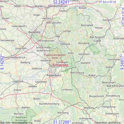
Schlangen GPS coordinates[2]
51° 48' 35.208" North, 8° 50' 45.78" East
| Map corner | latitude | longitude |
|---|---|---|
| Upper-left | 52.24241°, | 8.14292° |
| Center: | 51.80978°, | 8.84605° |
| Lower-right: | 51.37296°, | 9.54917° |
| Map W x H: | 96.7×96.7 km | = 60.1×60.1mi |
| max Lat: | 55.01917° ⇑29.9% North |
| Schlangen: | 51.80978° |
| min Lat: | ⇓70.1% South 47.40724° |
| min Long | Schlangen | max Long |
| 5.92978° | 8.84605° | 14.98853° |
| W 32.6%⇐ | ⇒67.4% E |
Elevation
Elevation of Schlangen is 169 m = 554 ft, and this is 80.1 m = 263 ft below average elevation for this country.
| Max E: |
1256 m = 4121 ft | 57.8% |
| Avg. | 249.1 m = 817 ft | |
| Schlangen | 169 m = 554 ft | |
Min E: |
-5 m = -16 ft | 42.2% |
See also: Germany elevation on elevation.city.
Geographical zone
Schlangen is located in North temperate zone (between Tropic of Cancer and the Arctic Circle). Distance of this North polar circle is 1640.5 km =1019.4 mi to North.| Distance of | km | miles | from Schlangen |
|---|---|---|---|
| North Pole | 4246.4 | 2638.6 | to North |
| Arctic Circle | 1640.5 | 1019.4 | to North |
| Tropic Cancer | 3154.8 | 1960.3 | to South |
| Equator | 5760.7 | 3579.5 | to South |


Nearby cities:
15 places around Schlangen: (largest is in red/bold)
• Altenbeken
8.3 km =5.2 mi,  127°
127°
• Augustdorf
13.6 km =8.5 mi,  324°
324°
• Bad Driburg
14.7 km =9.1 mi, 125°
• Bad Lippspringe
3.6 km =2.2 mi,  214°
214°
• Bad Meinberg
13.4 km =8.3 mi,  44°
44°
• Delbrück
20.1 km =12.5 mi,  255°
255°
• Detmold
14.4 km =8.9 mi,  7°
7°
• Horn
9.7 km =6 mi, 44°
• Horn-Bad Meinberg
11.6 km =7.2 mi, 43°
• Hövelhof
13.5 km =8.4 mi,  273°
273°
• Lage
20.6 km =12.8 mi,  349°
349°
• Nieheim
18.4 km =11.4 mi,  91°
91°
• Oerlinghausen
20.5 km =12.7 mi, 321°
• Paderborn
11.9 km =7.4 mi, 212°
• Steinheim
18.2 km =11.3 mi,  68°
68°
Sources, notices
• [Note1] Compared only with cities in Germany existing in our database
• [Src1] Map data: © OpenStreetMap contributors (CC-BY-SA)
• [Src2] Other city data from geonames.org with taken over terms of usage.
• [Src3] Geographical zone / Annual Mean Temperature by Robert A. Rohde @ Wikipedia
