Altenbeken geodata
Altenbeken (North Rhine-Westphalia) is a seat of a fourth-order administrative division; located in Germany in Europe/Berlin (GMT+2) time zone. With population of 9,716 people, there are 1666 cities with bigger population in this country. Compared to other cities in Germany, 69.5% of cities are located further ↓South; 66.1% of cities are located further →East and 53.1% of cities have lower elevation than Altenbeken. Note1
Administrative division(s):
- Level 1: North Rhine-Westphalia
- Level 2: Regierungsbezirk Detmold
- Level 3: Kreis Paderborn
- Level 4: Altenbeken


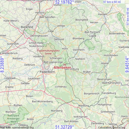
Altenbeken GPS coordinates[2]
51° 45' 52.38" North, 8° 56' 31.236" East
| Map corner | latitude | longitude |
|---|---|---|
| Upper-left | 52.19762°, | 8.23889° |
| Center: | 51.76455°, | 8.94201° |
| Lower-right: | 51.32729°, | 9.64514° |
| Map W x H: | 96.8×96.8 km | = 60.1×60.1mi |
| max Lat: | 55.01917° ⇑30.5% North |
| Altenbeken: | 51.76455° |
| min Lat: | ⇓69.5% South 47.40724° |
| min Long | Altenbeken | max Long |
| 5.92978° | 8.94201° | 14.98853° |
| W 33.9%⇐ | ⇒66.1% E |
Elevation
Elevation of Altenbeken is 247 m = 810 ft, and this is 2.1 m = 7 ft below average elevation for this country.
| Max E: |
1256 m = 4121 ft | 46.9% |
| Avg. | 249.1 m = 817 ft | |
| Altenbeken | 247 m = 810 ft | |
Min E: |
-5 m = -16 ft | 53.1% |
See also: Germany elevation on elevation.city.
Geographical zone
Altenbeken is located in North temperate zone (between Tropic of Cancer and the Arctic Circle). Distance of this North polar circle is 1645.5 km =1022.5 mi to North.| Distance of | km | miles | from Altenbeken |
|---|---|---|---|
| North Pole | 4251.4 | 2641.7 | to North |
| Arctic Circle | 1645.5 | 1022.5 | to North |
| Tropic Cancer | 3149.8 | 1957.2 | to South |
| Equator | 5755.7 | 3576.4 | to South |


Nearby cities:
15 places around Altenbeken: (largest is in red/bold)
• Bad Driburg
6.4 km =4 mi,  123°
123°
• Bad Lippspringe
8.9 km =5.5 mi,  283°
283°
• Bad Meinberg
14.9 km =9.3 mi,  10°
10°
• Brakel
17.6 km =10.9 mi,  107°
107°
• Detmold
19.9 km =12.4 mi,  346°
346°
• Horn
11.9 km =7.4 mi,  1°
1°
• Horn-Bad Meinberg
13.5 km =8.4 mi, 5°
• Hövelhof
20.9 km =13 mi,  286°
286°
• Lichtenau
16.7 km =10.4 mi,  190°
190°
• Nieheim
12.6 km =7.8 mi,  69°
69°
• Paderborn
13.9 km =8.6 mi,  248°
248°
• Schieder-Schwalenberg
21.4 km =13.3 mi,  54°
54°
• Schlangen
8.3 km =5.2 mi,  307°
307°
• Steinheim
15.6 km =9.7 mi,  41°
41°
• Willebadessen
16.8 km =10.4 mi,  157°
157°
Sources, notices
• [Note1] Compared only with cities in Germany existing in our database
• [Src1] Map data: © OpenStreetMap contributors (CC-BY-SA)
• [Src2] Other city data from geonames.org with taken over terms of usage.
• [Src3] Geographical zone / Annual Mean Temperature by Robert A. Rohde @ Wikipedia
