Bad Lippspringe geodata
Bad Lippspringe (North Rhine-Westphalia) is a populated place; located in Germany in Europe/Berlin (GMT+2) time zone. With population of 15,175 people, there are 1059 cities with bigger population in this country. Compared to other cities in Germany, 69.7% of cities are located further ↓South; 67.7% of cities are located further →East and 61.3% of cities have higher elevation than Bad Lippspringe. Note1
Administrative division(s):
- Level 1: North Rhine-Westphalia
- Level 2: Regierungsbezirk Detmold
- Level 3: Kreis Paderborn
- Level 4: Bad Lippspringe


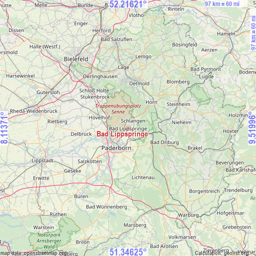
Bad Lippspringe GPS coordinates[2]
51° 46' 59.988" North, 8° 49' 0.588" East
| Map corner | latitude | longitude |
|---|---|---|
| Upper-left | 52.21621°, | 8.11371° |
| Center: | 51.78333°, | 8.81683° |
| Lower-right: | 51.34625°, | 9.51996° |
| Map W x H: | 96.7×96.7 km | = 60.1×60.1mi |
| max Lat: | 55.01917° ⇑30.3% North |
| Bad Lippspringe: | 51.78333° |
| min Lat: | ⇓69.7% South 47.40724° |
| min Long | Bad Lippspringe | max Long |
| 5.92978° | 8.81683° | 14.98853° |
| W 32.3%⇐ | ⇒67.7% E |
Elevation
Elevation of Bad Lippspringe is 144 m = 472 ft, and this is 105.1 m = 345 ft below average elevation for this country.
| Max E: |
1256 m = 4121 ft | 61.3% |
| Avg. | 249.1 m = 817 ft | |
| Bad Lippspringe | 144 m = 472 ft | |
Min E: |
-5 m = -16 ft | 38.7% |
See also: Germany elevation on elevation.city.
Geographical zone
Bad Lippspringe is located in North temperate zone (between Tropic of Cancer and the Arctic Circle). Distance of this North polar circle is 1643.4 km =1021.2 mi to North.| Distance of | km | miles | from Bad Lippspringe |
|---|---|---|---|
| North Pole | 4249.3 | 2640.4 | to North |
| Arctic Circle | 1643.4 | 1021.2 | to North |
| Tropic Cancer | 3151.8 | 1958.4 | to South |
| Equator | 5757.8 | 3577.7 | to South |


Nearby cities:
15 places around Bad Lippspringe: (largest is in red/bold)
• Altenbeken
8.9 km =5.5 mi,  103°
103°
• Augustdorf
15.2 km =9.4 mi,  337°
337°
• Bad Driburg
15 km =9.3 mi,  111°
111°
• Bad Meinberg
16.9 km =10.5 mi,  42°
42°
• Delbrück
17.6 km =10.9 mi,  263°
263°
• Detmold
17.7 km =11 mi,  12°
12°
• Horn
13.2 km =8.2 mi, 41°
• Horn-Bad Meinberg
15.1 km =9.4 mi, 41°
• Hövelhof
12.1 km =7.5 mi,  287°
287°
• Lichtenau
19.3 km =12 mi,  163°
163°
• Nieheim
20.5 km =12.7 mi,  83°
83°
• Paderborn
8.3 km =5.2 mi,  211°
211°
• Salzkotten
19.4 km =12.1 mi,  230°
230°
• Schlangen
3.6 km =2.2 mi,  34°
34°
• Steinheim
21.2 km =13.2 mi,  62°
62°
Sources, notices
• [Note1] Compared only with cities in Germany existing in our database
• [Src1] Map data: © OpenStreetMap contributors (CC-BY-SA)
• [Src2] Other city data from geonames.org with taken over terms of usage.
• [Src3] Geographical zone / Annual Mean Temperature by Robert A. Rohde @ Wikipedia
