Aresing geodata
Aresing (Bavaria) is a seat of a fourth-order administrative division; located in Germany in Europe/Berlin (GMT+2) time zone. In our database, there are 11009 cities with bigger population. Compared to other cities in Germany, 88.7% of cities are located further ↑North; 71.3% of cities are located further ←West and 79.3% of cities have lower elevation than Aresing. Note1
Administrative division(s):
- Level 1: Bavaria
- Level 2: Upper Bavaria
- Level 3: Landkreis Neuburg-Schrobenhausen
- Level 4: Aresing


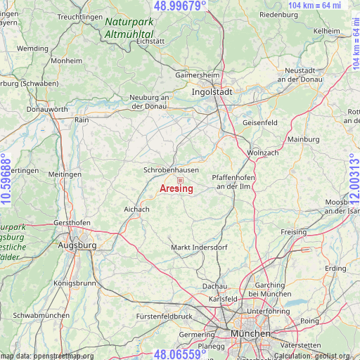
Aresing GPS coordinates[2]
48° 31' 59.988" North, 11° 18' 0" East
| Map corner | latitude | longitude |
|---|---|---|
| Upper-left | 48.99679°, | 10.59688° |
| Center: | 48.53333°, | 11.3° |
| Lower-right: | 48.06559°, | 12.00313° |
| Map W x H: | 103.5×103.5 km | = 64.3×64.3mi |
| max Lat: | 55.01917° ⇑88.7% North |
| Aresing: | 48.53333° |
| min Lat: | ⇓11.3% South 47.40724° |
| min Long | Aresing | max Long |
| 5.92978° | 11.3° | 14.98853° |
| W 71.3%⇐ | ⇒28.7% E |
Elevation
Elevation of Aresing is 429 m = 1407 ft, and this is 179.9 m = 590 ft above average elevation for this country.
| Max E: |
1256 m = 4121 ft | 20.7% |
| Aresing | 429 m 1407 ft | |
| Avg. | 249.1 m = 817 ft | |
Min E: |
-5 m = -16 ft | 79.3% |
See also: Germany elevation on elevation.city.
Geographical zone
Aresing is located in North temperate zone (between Tropic of Cancer and the Arctic Circle). Distance of this North polar circle is 2004.8 km =1245.7 mi to North.| Distance of | km | miles | from Aresing |
|---|---|---|---|
| North Pole | 4610.7 | 2865 | to North |
| Arctic Circle | 2004.8 | 1245.7 | to North |
| Tropic Cancer | 2790.5 | 1733.9 | to South |
| Equator | 5396.4 | 3353.2 | to South |


Nearby cities:
15 places around Aresing: (largest is in red/bold)
• Aichach
14.8 km =9.2 mi,  235°
235°
• Berg im Gau
11.7 km =7.3 mi,  341°
341°
• Brunnen
10.7 km =6.6 mi,  3°
3°
• Gachenbach
6.2 km =3.9 mi,  232°
232°
• Gerolsbach
6.4 km =4 mi,  134°
134°
• Hilgertshausen-Tandern
12.2 km =7.6 mi,  160°
160°
• Inchenhofen
13.8 km =8.6 mi,  260°
260°
• Jetzendorf
14.1 km =8.8 mi,  142°
142°
• Kühbach
9.6 km =6 mi, 240°
• Langenmosen
10.3 km =6.4 mi,  322°
322°
• Ried
6.9 km =4.3 mi,  204°
204°
• Scheyern
12.8 km =8 mi,  106°
106°
• Schiltberg
8.7 km =5.4 mi,  205°
205°
• Schrobenhausen
4.2 km =2.6 mi, 316°
• Waidhofen
5.5 km =3.4 mi,  28°
28°
Sources, notices
• [Note1] Compared only with cities in Germany existing in our database
• [Src1] Map data: © OpenStreetMap contributors (CC-BY-SA)
• [Src2] Other city data from geonames.org with taken over terms of usage.
• [Src3] Geographical zone / Annual Mean Temperature by Robert A. Rohde @ Wikipedia
