Schrobenhausen geodata
Schrobenhausen (Bavaria) is a populated place; located in Germany in Europe/Berlin (GMT+2) time zone. With population of 16,143 people, there are 988 cities with bigger population in this country. Compared to other cities in Germany, 88.3% of cities are located further ↑North; 70.8% of cities are located further ←West and 77.2% of cities have lower elevation than Schrobenhausen. Note1
Administrative division(s):
- Level 1: Bavaria
- Level 2: Upper Bavaria
- Level 3: Landkreis Neuburg-Schrobenhausen
- Level 4: Schrobenhausen


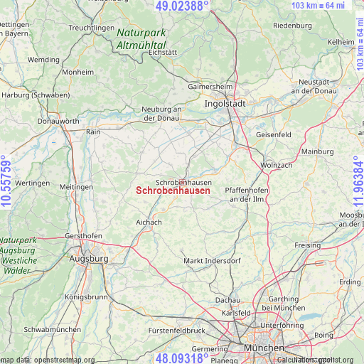
Schrobenhausen GPS coordinates[2]
48° 33' 38.412" North, 11° 15' 38.556" East
| Map corner | latitude | longitude |
|---|---|---|
| Upper-left | 49.02388°, | 10.55759° |
| Center: | 48.56067°, | 11.26071° |
| Lower-right: | 48.09318°, | 11.96384° |
| Map W x H: | 103.5×103.5 km | = 64.3×64.3mi |
| max Lat: | 55.01917° ⇑88.3% North |
| Schrobenhausen: | 48.56067° |
| min Lat: | ⇓11.7% South 47.40724° |
| min Long | Schrobenhausen | max Long |
| 5.92978° | 11.26071° | 14.98853° |
| W 70.8%⇐ | ⇒29.2% E |
Elevation
Elevation of Schrobenhausen is 414 m = 1358 ft, and this is 164.9 m = 541 ft above average elevation for this country.
| Max E: |
1256 m = 4121 ft | 22.8% |
| Schrobenhausen | 414 m 1358 ft | |
| Avg. | 249.1 m = 817 ft | |
Min E: |
-5 m = -16 ft | 77.2% |
See also: Germany elevation on elevation.city.
Geographical zone
Schrobenhausen is located in North temperate zone (between Tropic of Cancer and the Arctic Circle). Distance of this North polar circle is 2001.7 km =1243.8 mi to North.| Distance of | km | miles | from Schrobenhausen |
|---|---|---|---|
| North Pole | 4607.6 | 2863 | to North |
| Arctic Circle | 2001.7 | 1243.8 | to North |
| Tropic Cancer | 2793.5 | 1735.8 | to South |
| Equator | 5399.4 | 3355 | to South |


Nearby cities:
15 places around Schrobenhausen: (largest is in red/bold)
• Aichach
14.8 km =9.2 mi,  219°
219°
• Aresing
4.2 km =2.6 mi,  136°
136°
• Berg im Gau
8.1 km =5 mi,  354°
354°
• Brunnen
8.4 km =5.2 mi,  25°
25°
• Ehekirchen
14.3 km =8.9 mi,  304°
304°
• Gachenbach
7 km =4.3 mi,  196°
196°
• Gerolsbach
10.6 km =6.6 mi, 135°
• Inchenhofen
12 km =7.5 mi,  243°
243°
• Karlshuld
13.6 km =8.5 mi,  7°
7°
• Kühbach
9.5 km =5.9 mi, 215°
• Langenmosen
6.2 km =3.9 mi,  325°
325°
• Pöttmes
13 km =8.1 mi,  281°
281°
• Ried
9.3 km =5.8 mi,  180°
180°
• Schiltberg
10.9 km =6.8 mi, 184°
• Waidhofen
5.8 km =3.6 mi,  71°
71°
Sources, notices
• [Note1] Compared only with cities in Germany existing in our database
• [Src1] Map data: © OpenStreetMap contributors (CC-BY-SA)
• [Src2] Other city data from geonames.org with taken over terms of usage.
• [Src3] Geographical zone / Annual Mean Temperature by Robert A. Rohde @ Wikipedia
