Niedermohr geodata
Niedermohr (Rheinland-Pfalz) is a seat of a fourth-order administrative division; located in Germany in Europe/Berlin (GMT+2) time zone. With population of 1,523 people, there are 5836 cities with bigger population in this country. Compared to other cities in Germany, 76.3% of cities are located further ↑North; 87.5% of cities are located further →East and 50.3% of cities have higher elevation than Niedermohr. Note1
Administrative division(s):
- Level 1: Rheinland-Pfalz
- Level 3: Landkreis Kaiserslautern
- Level 4: Niedermohr


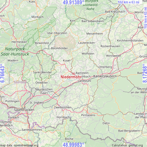
Niedermohr GPS coordinates[2]
49° 27' 32.364" North, 7° 28' 10.38" East
| Map corner | latitude | longitude |
|---|---|---|
| Upper-left | 49.91389°, | 6.76643° |
| Center: | 49.45899°, | 7.46955° |
| Lower-right: | 48.99983°, | 8.17268° |
| Map W x H: | 101.6×101.6 km | = 63.1×63.1mi |
| max Lat: | 55.01917° ⇑76.3% North |
| Niedermohr: | 49.45899° |
| min Lat: | ⇓23.7% South 47.40724° |
| min Long | Niedermohr | max Long |
| 5.92978° | 7.46955° | 14.98853° |
| W 12.5%⇐ | ⇒87.5% E |
Elevation
Elevation of Niedermohr is 223 m = 732 ft, and this is 26.1 m = 86 ft below average elevation for this country.
| Max E: |
1256 m = 4121 ft | 50.3% |
| Avg. | 249.1 m = 817 ft | |
| Niedermohr | 223 m = 732 ft | |
Min E: |
-5 m = -16 ft | 49.7% |
See also: Germany elevation on elevation.city.
Geographical zone
Niedermohr is located in North temperate zone (between Tropic of Cancer and the Arctic Circle). Distance of this North polar circle is 1901.8 km =1181.7 mi to North.| Distance of | km | miles | from Niedermohr |
|---|---|---|---|
| North Pole | 4507.7 | 2801 | to North |
| Arctic Circle | 1901.8 | 1181.7 | to North |
| Tropic Cancer | 2893.4 | 1797.9 | to South |
| Equator | 5499.3 | 3417.1 | to South |


Nearby cities:
15 places around Niedermohr: (largest is in red/bold)
• Börsborn
5.8 km =3.6 mi,  240°
240°
• Etschberg
6.9 km =4.3 mi,  337°
337°
• Glan-Münchweiler
2.5 km =1.6 mi,  306°
306°
• Gries
6.9 km =4.3 mi,  226°
226°
• Hauptstuhl
6.6 km =4.1 mi,  171°
171°
• Hütschenhausen
4.8 km =3 mi, 168°
• Kottweiler-Schwanden
5.3 km =3.3 mi,  59°
59°
• Matzenbach
4.6 km =2.9 mi,  357°
357°
• Nanzdietschweiler
1.7 km =1.1 mi, 234°
• Neunkirchen am Potzberg
4.7 km =2.9 mi,  12°
12°
• Quirnbach
4 km =2.5 mi,  296°
296°
• Ramstein-Miesenbach
6.4 km =4 mi,  104°
104°
• Rehweiler
3.6 km =2.2 mi,  326°
326°
• Steinwenden
4.2 km =2.6 mi,  92°
92°
• Theisbergstegen
6.7 km =4.2 mi,  346°
346°
Sources, notices
• [Note1] Compared only with cities in Germany existing in our database
• [Src1] Map data: © OpenStreetMap contributors (CC-BY-SA)
• [Src2] Other city data from geonames.org with taken over terms of usage.
• [Src3] Geographical zone / Annual Mean Temperature by Robert A. Rohde @ Wikipedia
