Rathmannsdorf geodata
Rathmannsdorf (Saxony) is a seat of a fourth-order administrative division; located in Germany in Europe/Berlin (GMT+2) time zone. With population of 1,155 people, there are 6689 cities with bigger population in this country. Compared to other cities in Germany, 56.7% of cities are located further ↓South; 98.5% of cities are located further ←West and 51.6% of cities have lower elevation than Rathmannsdorf. Note1
Administrative division(s):
- Level 1: Saxony
- Level 3: Landkreis Sächsische Schweiz
- Level 4: Rathmannsdorf


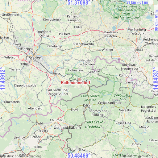
Rathmannsdorf GPS coordinates[2]
50° 55' 47.748" North, 14° 8' 32.064" East
| Map corner | latitude | longitude |
|---|---|---|
| Upper-left | 51.37098°, | 13.43912° |
| Center: | 50.92993°, | 14.14224° |
| Lower-right: | 50.48466°, | 14.84537° |
| Map W x H: | 98.5×98.5 km | = 61.2×61.2mi |
| max Lat: | 55.01917° ⇑43.3% North |
| Rathmannsdorf: | 50.92993° |
| min Lat: | ⇓56.7% South 47.40724° |
| min Long | Rathmannsdorf | max Long |
| 5.92978° | 14.14224° | 14.98853° |
| W 98.5%⇐ | ⇒1.5% E |
Elevation
Elevation of Rathmannsdorf is 237 m = 778 ft, and this is 12.1 m = 40 ft below average elevation for this country.
| Max E: |
1256 m = 4121 ft | 48.4% |
| Avg. | 249.1 m = 817 ft | |
| Rathmannsdorf | 237 m = 778 ft | |
Min E: |
-5 m = -16 ft | 51.6% |
See also: Germany elevation on elevation.city.
Geographical zone
Rathmannsdorf is located in North temperate zone (between Tropic of Cancer and the Arctic Circle). Distance of this North polar circle is 1738.3 km =1080.1 mi to North.| Distance of | km | miles | from Rathmannsdorf |
|---|---|---|---|
| North Pole | 4344.2 | 2699.4 | to North |
| Arctic Circle | 1738.3 | 1080.1 | to North |
| Tropic Cancer | 3057 | 1899.5 | to South |
| Equator | 5662.9 | 3518.8 | to South |


Nearby cities:
15 places around Rathmannsdorf: (largest is in red/bold)
• Bad Schandau
1.7 km =1.1 mi,  147°
147°
• Berthelsdorf
14.1 km =8.8 mi,  23°
23°
• Dohma
14.7 km =9.1 mi,  264°
264°
• Dürrröhrsdorf
15.4 km =9.6 mi,  318°
318°
• Hohnstein
5.9 km =3.7 mi,  340°
340°
• Kurort Gohrisch
3.2 km =2 mi,  231°
231°
• Königstein
5.2 km =3.2 mi,  252°
252°
• Lohmen
11.7 km =7.3 mi,  303°
303°
• Neustadt in Sachsen
12.2 km =7.6 mi,  25°
25°
• Pirna
14.7 km =9.1 mi,  282°
282°
• Porschdorf
1.7 km =1.1 mi, 320°
• Sebnitz
10.6 km =6.6 mi,  61°
61°
• Stadt Wehlen
8.4 km =5.2 mi,  291°
291°
• Stolpen
14 km =8.7 mi, 341°
• Struppen
8.8 km =5.5 mi,  272°
272°
Sources, notices
• [Note1] Compared only with cities in Germany existing in our database
• [Src1] Map data: © OpenStreetMap contributors (CC-BY-SA)
• [Src2] Other city data from geonames.org with taken over terms of usage.
• [Src3] Geographical zone / Annual Mean Temperature by Robert A. Rohde @ Wikipedia
