Königstein geodata
Königstein (Saxony) is a populated place; located in Germany in Europe/Berlin (GMT+2) time zone. With population of 3,011 people, there are 3989 cities with bigger population in this country. Compared to other cities in Germany, 56.4% of cities are located further ↓South; 98.2% of cities are located further ←West and 63.9% of cities have higher elevation than Königstein. Note1
Administrative division(s):
- Level 1: Saxony
- Level 3: Landkreis Sächsische Schweiz
- Level 4: Königstein/Sächs. Schw.


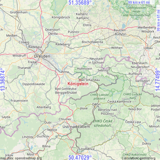
Königstein GPS coordinates[2]
50° 54' 56.52" North, 14° 4' 18.696" East
| Map corner | latitude | longitude |
|---|---|---|
| Upper-left | 51.35689°, | 13.36874° |
| Center: | 50.9157°, | 14.07186° |
| Lower-right: | 50.47029°, | 14.77499° |
| Map W x H: | 98.6×98.6 km | = 61.3×61.3mi |
| max Lat: | 55.01917° ⇑43.6% North |
| Königstein: | 50.9157° |
| min Lat: | ⇓56.4% South 47.40724° |
| min Long | Königstein | max Long |
| 5.92978° | 14.07186° | 14.98853° |
| W 98.2%⇐ | ⇒1.8% E |
Elevation
Elevation of Königstein is 127 m = 417 ft, and this is 122.1 m = 401 ft below average elevation for this country.
| Max E: |
1256 m = 4121 ft | 63.9% |
| Avg. | 249.1 m = 817 ft | |
| Königstein | 127 m = 417 ft | |
Min E: |
-5 m = -16 ft | 36.1% |
See also: Germany elevation on elevation.city.
Geographical zone
Königstein is located in North temperate zone (between Tropic of Cancer and the Arctic Circle). Distance of this North polar circle is 1739.9 km =1081.1 mi to North.| Distance of | km | miles | from Königstein |
|---|---|---|---|
| North Pole | 4345.8 | 2700.4 | to North |
| Arctic Circle | 1739.9 | 1081.1 | to North |
| Tropic Cancer | 3055.4 | 1898.5 | to South |
| Equator | 5661.3 | 3517.8 | to South |


Nearby cities:
15 places around Königstein: (largest is in red/bold)
• Bad Schandau
5.8 km =3.6 mi,  88°
88°
• Dohma
9.7 km =6 mi,  270°
270°
• Dohna
15.6 km =9.7 mi,  286°
286°
• Dürrröhrsdorf
14.1 km =8.8 mi,  338°
338°
• Heidenau
15.6 km =9.7 mi, 293°
• Hohnstein
7.7 km =4.8 mi,  22°
22°
• Kurort Gohrisch
2.5 km =1.6 mi,  98°
98°
• Lohmen
9.4 km =5.8 mi,  329°
329°
• Pirna
10.6 km =6.6 mi,  296°
296°
• Porschdorf
4.8 km =3 mi,  53°
53°
• Rathmannsdorf
5.2 km =3.2 mi,  72°
72°
• Sebnitz
15.8 km =9.8 mi, 65°
• Stadt Wehlen
5.5 km =3.4 mi, 328°
• Stolpen
14.8 km =9.2 mi,  2°
2°
• Struppen
4.3 km =2.7 mi, 296°
Sources, notices
• [Note1] Compared only with cities in Germany existing in our database
• [Src1] Map data: © OpenStreetMap contributors (CC-BY-SA)
• [Src2] Other city data from geonames.org with taken over terms of usage.
• [Src3] Geographical zone / Annual Mean Temperature by Robert A. Rohde @ Wikipedia
