Falkenberg geodata
Falkenberg (Bavaria) is a seat of a fourth-order administrative division; located in Germany in Europe/Berlin (GMT+2) time zone. With population of 3,956 people, there are 3324 cities with bigger population in this country. Compared to other cities in Germany, 89.5% of cities are located further ↑North; 90.1% of cities are located further ←West and 86% of cities have lower elevation than Falkenberg. Note1
Administrative division(s):
- Level 1: Bavaria
- Level 2: Lower Bavaria
- Level 3: Landkreis Rottal-Inn
- Level 4: Falkenberg


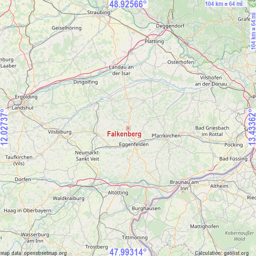
Falkenberg GPS coordinates[2]
48° 27' 41.544" North, 12° 43' 49.764" East
| Map corner | latitude | longitude |
|---|---|---|
| Upper-left | 48.92566°, | 12.02737° |
| Center: | 48.46154°, | 12.73049° |
| Lower-right: | 47.99314°, | 13.43362° |
| Map W x H: | 103.7×103.7 km | = 64.4×64.4mi |
| max Lat: | 55.01917° ⇑89.5% North |
| Falkenberg: | 48.46154° |
| min Lat: | ⇓10.5% South 47.40724° |
| min Long | Falkenberg | max Long |
| 5.92978° | 12.73049° | 14.98853° |
| W 90.1%⇐ | ⇒9.9% E |
Elevation
Elevation of Falkenberg is 478 m = 1568 ft, and this is 228.9 m = 751 ft above average elevation for this country.
| Max E: |
1256 m = 4121 ft | 14% |
| Falkenberg | 478 m 1568 ft | |
| Avg. | 249.1 m = 817 ft | |
Min E: |
-5 m = -16 ft | 86% |
See also: Germany elevation on elevation.city.
Geographical zone
Falkenberg is located in North temperate zone (between Tropic of Cancer and the Arctic Circle). Distance of this North polar circle is 2012.8 km =1250.7 mi to North.| Distance of | km | miles | from Falkenberg |
|---|---|---|---|
| North Pole | 4618.6 | 2869.9 | to North |
| Arctic Circle | 2012.8 | 1250.7 | to North |
| Tropic Cancer | 2782.5 | 1729 | to South |
| Equator | 5388.4 | 3348.2 | to South |


Nearby cities:
15 places around Falkenberg: (largest is in red/bold)
• Arnstorf
12.5 km =7.8 mi,  30°
30°
• Eggenfelden
6.6 km =4.1 mi,  162°
162°
• Gangkofen
12.6 km =7.8 mi,  257°
257°
• Hebertsfelden
9.2 km =5.7 mi,  132°
132°
• Malgersdorf
8.1 km =5 mi,  10°
10°
• Massing
11.9 km =7.4 mi,  228°
228°
• Mitterskirchen
12.4 km =7.7 mi,  179°
179°
• Postmünster
13.5 km =8.4 mi,  111°
111°
• Reisbach
14.2 km =8.8 mi,  327°
327°
• Rimbach
6 km =3.7 mi,  275°
275°
• Ruhstorf
9.4 km =5.8 mi,  338°
338°
• Schönau
9.1 km =5.7 mi,  74°
74°
• Simbach
11.6 km =7.2 mi,  3°
3°
• Unterdietfurt
9.9 km =6.2 mi,  208°
208°
• Wurmannsquick
12.7 km =7.9 mi, 161°
Sources, notices
• [Note1] Compared only with cities in Germany existing in our database
• [Src1] Map data: © OpenStreetMap contributors (CC-BY-SA)
• [Src2] Other city data from geonames.org with taken over terms of usage.
• [Src3] Geographical zone / Annual Mean Temperature by Robert A. Rohde @ Wikipedia
