Pöttmes geodata
Pöttmes (Bavaria) is a populated place; located in Germany in Europe/Berlin (GMT+2) time zone. With population of 6,315 people, there are 2360 cities with bigger population in this country. Compared to other cities in Germany, 88% of cities are located further ↑North; 68.3% of cities are located further ←West and 76.4% of cities have lower elevation than Pöttmes. Note1
Administrative division(s):
- Level 1: Bavaria
- Level 2: Swabia
- Level 3: Landkreis Aichach-Friedberg
- Level 4: Pöttmes, Markt


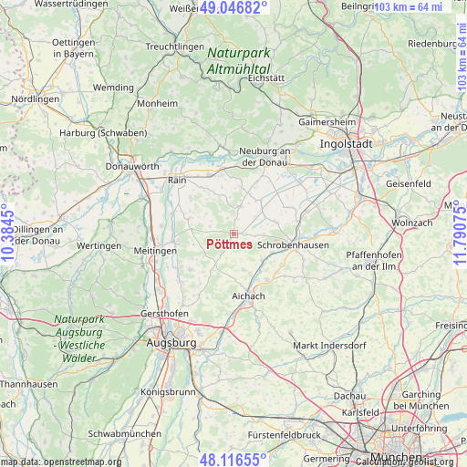
Pöttmes GPS coordinates[2]
48° 35' 1.788" North, 11° 5' 15.432" East
| Map corner | latitude | longitude |
|---|---|---|
| Upper-left | 49.04682°, | 10.3845° |
| Center: | 48.58383°, | 11.08762° |
| Lower-right: | 48.11655°, | 11.79075° |
| Map W x H: | 103.4×103.4 km | = 64.2×64.2mi |
| max Lat: | 55.01917° ⇑88% North |
| Pöttmes: | 48.58383° |
| min Lat: | ⇓12% South 47.40724° |
| min Long | Pöttmes | max Long |
| 5.92978° | 11.08762° | 14.98853° |
| W 68.3%⇐ | ⇒31.7% E |
Elevation
Elevation of Pöttmes is 408 m = 1339 ft, and this is 158.9 m = 521 ft above average elevation for this country.
| Max E: |
1256 m = 4121 ft | 23.6% |
| Pöttmes | 408 m 1339 ft | |
| Avg. | 249.1 m = 817 ft | |
Min E: |
-5 m = -16 ft | 76.4% |
See also: Germany elevation on elevation.city.
Geographical zone
Pöttmes is located in North temperate zone (between Tropic of Cancer and the Arctic Circle). Distance of this North polar circle is 1999.2 km =1242.2 mi to North.| Distance of | km | miles | from Pöttmes |
|---|---|---|---|
| North Pole | 4605 | 2861.4 | to North |
| Arctic Circle | 1999.2 | 1242.2 | to North |
| Tropic Cancer | 2796.1 | 1737.4 | to South |
| Equator | 5402 | 3356.6 | to South |


Nearby cities:
15 places around Pöttmes: (largest is in red/bold)
• Aindling
12.6 km =7.8 mi,  231°
231°
• Berg im Gau
13.1 km =8.1 mi,  65°
65°
• Burgheim
14 km =8.7 mi,  337°
337°
• Ehekirchen
5.6 km =3.5 mi,  9°
9°
• Gachenbach
14.2 km =8.8 mi,  130°
130°
• Hollenbach
11.3 km =7 mi,  187°
187°
• Holzheim
10.7 km =6.6 mi,  286°
286°
• Inchenhofen
8.1 km =5 mi,  165°
165°
• Kühbach
12.6 km =7.8 mi,  144°
144°
• Langenmosen
9.6 km =6 mi, 74°
• Petersdorf
8.5 km =5.3 mi,  208°
208°
• Rohrenfels
12.5 km =7.8 mi,  23°
23°
• Schrobenhausen
13 km =8.1 mi,  101°
101°
• Thierhaupten
13.3 km =8.3 mi,  261°
261°
• Todtenweis
13.9 km =8.6 mi,  237°
237°
Sources, notices
• [Note1] Compared only with cities in Germany existing in our database
• [Src1] Map data: © OpenStreetMap contributors (CC-BY-SA)
• [Src2] Other city data from geonames.org with taken over terms of usage.
• [Src3] Geographical zone / Annual Mean Temperature by Robert A. Rohde @ Wikipedia
