Velden geodata
Velden (Bavaria) is a populated place; located in Germany in Europe/Berlin (GMT+2) time zone. With population of 1,887 people, there are 5223 cities with bigger population in this country. Compared to other cities in Germany, 73.5% of cities are located further ↑North; 74.4% of cities are located further ←West and 73.7% of cities have lower elevation than Velden. Note1
Administrative division(s):
- Level 1: Bavaria
- Level 2: Regierungsbezirk Mittelfranken
- Level 3: Nürnberger Land
- Level 4: Velden


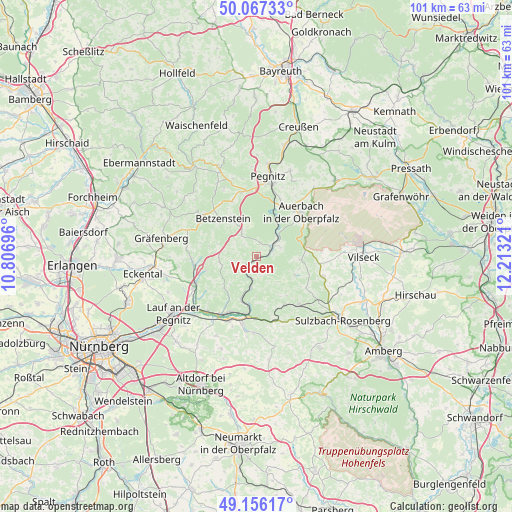
Velden GPS coordinates[2]
49° 36' 49.968" North, 11° 30' 36.288" East
| Map corner | latitude | longitude |
|---|---|---|
| Upper-left | 50.06733°, | 10.80696° |
| Center: | 49.61388°, | 11.51008° |
| Lower-right: | 49.15617°, | 12.21321° |
| Map W x H: | 101.3×101.3 km | = 62.9×62.9mi |
| max Lat: | 55.01917° ⇑73.5% North |
| Velden: | 49.61388° |
| min Lat: | ⇓26.5% South 47.40724° |
| min Long | Velden | max Long |
| 5.92978° | 11.51008° | 14.98853° |
| W 74.4%⇐ | ⇒25.6% E |
Elevation
Elevation of Velden is 388 m = 1273 ft, and this is 138.9 m = 456 ft above average elevation for this country.
| Max E: |
1256 m = 4121 ft | 26.3% |
| Velden | 388 m 1273 ft | |
| Avg. | 249.1 m = 817 ft | |
Min E: |
-5 m = -16 ft | 73.7% |
See also: Germany elevation on elevation.city.
Geographical zone
Velden is located in North temperate zone (between Tropic of Cancer and the Arctic Circle). Distance of this North polar circle is 1884.6 km =1171 mi to North.| Distance of | km | miles | from Velden |
|---|---|---|---|
| North Pole | 4490.5 | 2790.3 | to North |
| Arctic Circle | 1884.6 | 1171 | to North |
| Tropic Cancer | 2910.6 | 1808.6 | to South |
| Equator | 5516.5 | 3427.8 | to South |


Nearby cities:
15 places around Velden: (largest is in red/bold)
• Auerbach
12.4 km =7.7 mi,  45°
45°
• Edelsfeld
14 km =8.7 mi,  107°
107°
• Etzelwang
11 km =6.8 mi,  150°
150°
• Happurg
13.7 km =8.5 mi,  191°
191°
• Hartenstein
1.6 km =1 mi,  162°
162°
• Hersbruck
12.8 km =8 mi,  206°
206°
• Hirschbach
7.3 km =4.5 mi,  166°
166°
• Kirchensittenbach
9 km =5.6 mi,  224°
224°
• Königstein
8.8 km =5.5 mi,  93°
93°
• Neuhaus an der Pegnitz
3.3 km =2.1 mi,  61°
61°
• Pommelsbrunn
12.2 km =7.6 mi,  179°
179°
• Schnaittach
13.5 km =8.4 mi,  243°
243°
• Simmelsdorf
12.5 km =7.8 mi,  261°
261°
• Vorra
6.4 km =4 mi, 190°
• Weigendorf
13.6 km =8.5 mi, 161°
Sources, notices
• [Note1] Compared only with cities in Germany existing in our database
• [Src1] Map data: © OpenStreetMap contributors (CC-BY-SA)
• [Src2] Other city data from geonames.org with taken over terms of usage.
• [Src3] Geographical zone / Annual Mean Temperature by Robert A. Rohde @ Wikipedia
