Wüstenrot geodata
Wüstenrot (Baden-Württemberg) is a seat of a fourth-order administrative division; located in Germany in Europe/Berlin (GMT+2) time zone. With population of 6,770 people, there are 2245 cities with bigger population in this country. Compared to other cities in Germany, 82% of cities are located further ↑North; 58.5% of cities are located further →East and 88.1% of cities have lower elevation than Wüstenrot. Note1
Administrative division(s):
- Level 1: Baden-Württemberg
- Level 2: Regierungsbezirk Stuttgart
- Level 3: Landkreis Heilbronn
- Level 4: Wüstenrot


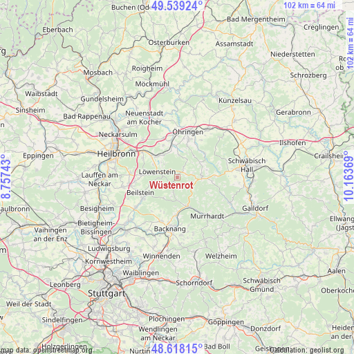
Wüstenrot GPS coordinates[2]
49° 4' 50.988" North, 9° 27' 38.016" East
| Map corner | latitude | longitude |
|---|---|---|
| Upper-left | 49.53924°, | 8.75743° |
| Center: | 49.08083°, | 9.46056° |
| Lower-right: | 48.61815°, | 10.16369° |
| Map W x H: | 102.4×102.4 km | = 63.6×63.6mi |
| max Lat: | 55.01917° ⇑82% North |
| Wüstenrot: | 49.08083° |
| min Lat: | ⇓18% South 47.40724° |
| min Long | Wüstenrot | max Long |
| 5.92978° | 9.46056° | 14.98853° |
| W 41.5%⇐ | ⇒58.5% E |
Elevation
Elevation of Wüstenrot is 495 m = 1624 ft, and this is 245.9 m = 807 ft above average elevation for this country.
| Max E: |
1256 m = 4121 ft | 11.9% |
| Wüstenrot | 495 m 1624 ft | |
| Avg. | 249.1 m = 817 ft | |
Min E: |
-5 m = -16 ft | 88.1% |
See also: Germany elevation on elevation.city.
Geographical zone
Wüstenrot is located in North temperate zone (between Tropic of Cancer and the Arctic Circle). Distance of this North polar circle is 1943.9 km =1207.9 mi to North.| Distance of | km | miles | from Wüstenrot |
|---|---|---|---|
| North Pole | 4549.8 | 2827.1 | to North |
| Arctic Circle | 1943.9 | 1207.9 | to North |
| Tropic Cancer | 2851.4 | 1771.8 | to South |
| Equator | 5457.3 | 3391 | to South |


Nearby cities:
15 places around Wüstenrot: (largest is in red/bold)
• Abstatt
12.5 km =7.8 mi,  263°
263°
• Aspach
13.4 km =8.3 mi,  199°
199°
• Beilstein
11.6 km =7.2 mi,  247°
247°
• Bretzfeld
11.1 km =6.9 mi,  351°
351°
• Ellhofen
12.5 km =7.8 mi,  305°
305°
• Großerlach
4.9 km =3 mi,  128°
128°
• Lehrensteinsfeld
11.2 km =7 mi,  299°
299°
• Löwenstein
6.1 km =3.8 mi,  285°
285°
• Mainhardt
7 km =4.3 mi,  94°
94°
• Oberstenfeld
11.9 km =7.4 mi,  239°
239°
• Oppenweiler
10.9 km =6.8 mi,  180°
180°
• Pfedelbach
11.3 km =7 mi,  16°
16°
• Spiegelberg
4.6 km =2.9 mi,  194°
194°
• Sulzbach an der Murr
9.1 km =5.7 mi,  161°
161°
• Untergruppenbach
13.5 km =8.4 mi,  274°
274°
Sources, notices
• [Note1] Compared only with cities in Germany existing in our database
• [Src1] Map data: © OpenStreetMap contributors (CC-BY-SA)
• [Src2] Other city data from geonames.org with taken over terms of usage.
• [Src3] Geographical zone / Annual Mean Temperature by Robert A. Rohde @ Wikipedia
