Bretzfeld geodata
Bretzfeld (Baden-Württemberg) is a seat of a fourth-order administrative division; located in Germany in Europe/Berlin (GMT+2) time zone. With population of 12,162 people, there are 1344 cities with bigger population in this country. Compared to other cities in Germany, 80.7% of cities are located further ↑North; 58.7% of cities are located further →East and 52.1% of cities have higher elevation than Bretzfeld. Note1
Administrative division(s):
- Level 1: Baden-Württemberg
- Level 2: Regierungsbezirk Stuttgart
- Level 3: Hohenlohekreis
- Level 4: Bretzfeld


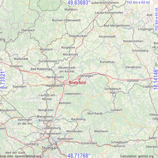
Bretzfeld GPS coordinates[2]
49° 10' 45.984" North, 9° 26' 17.988" East
| Map corner | latitude | longitude |
|---|---|---|
| Upper-left | 49.63693°, | 8.73521° |
| Center: | 49.17944°, | 9.43833° |
| Lower-right: | 48.71768°, | 10.14146° |
| Map W x H: | 102.2×102.2 km | = 63.5×63.5mi |
| max Lat: | 55.01917° ⇑80.7% North |
| Bretzfeld: | 49.17944° |
| min Lat: | ⇓19.3% South 47.40724° |
| min Long | Bretzfeld | max Long |
| 5.92978° | 9.43833° | 14.98853° |
| W 41.3%⇐ | ⇒58.7% E |
Elevation
Elevation of Bretzfeld is 211 m = 692 ft, and this is 38.1 m = 125 ft below average elevation for this country.
| Max E: |
1256 m = 4121 ft | 52.1% |
| Avg. | 249.1 m = 817 ft | |
| Bretzfeld | 211 m = 692 ft | |
Min E: |
-5 m = -16 ft | 47.9% |
See also: Germany elevation on elevation.city.
Geographical zone
Bretzfeld is located in North temperate zone (between Tropic of Cancer and the Arctic Circle). Distance of this North polar circle is 1932.9 km =1201 mi to North.| Distance of | km | miles | from Bretzfeld |
|---|---|---|---|
| North Pole | 4538.8 | 2820.3 | to North |
| Arctic Circle | 1932.9 | 1201 | to North |
| Tropic Cancer | 2862.3 | 1778.6 | to South |
| Equator | 5468.2 | 3397.8 | to South |


Nearby cities:
15 places around Bretzfeld: (largest is in red/bold)
• Eberstadt
8.5 km =5.3 mi,  270°
270°
• Ellhofen
9.2 km =5.7 mi,  246°
246°
• Erlenbach
12.4 km =7.7 mi, 266°
• Jagsthausen
14.7 km =9.1 mi,  8°
8°
• Langenbrettach
5.4 km =3.4 mi,  344°
344°
• Lehrensteinsfeld
9.7 km =6 mi,  236°
236°
• Löwenstein
10.2 km =6.3 mi,  204°
204°
• Mainhardt
14.3 km =8.9 mi,  143°
143°
• Neuenstadt am Kocher
9.9 km =6.2 mi,  308°
308°
• Neuenstein
10.7 km =6.6 mi,  74°
74°
• Pfedelbach
4.8 km =3 mi,  91°
91°
• Weinsberg
11.4 km =7.1 mi, 254°
• Wüstenrot
11.1 km =6.9 mi,  171°
171°
• Zweiflingen
10.3 km =6.4 mi,  34°
34°
• Öhringen
5.4 km =3.4 mi, 66°
Sources, notices
• [Note1] Compared only with cities in Germany existing in our database
• [Src1] Map data: © OpenStreetMap contributors (CC-BY-SA)
• [Src2] Other city data from geonames.org with taken over terms of usage.
• [Src3] Geographical zone / Annual Mean Temperature by Robert A. Rohde @ Wikipedia
