Manching geodata
Manching (Bavaria) is a populated place; located in Germany in Europe/Berlin (GMT+2) time zone. With population of 11,239 people, there are 1471 cities with bigger population in this country. Compared to other cities in Germany, 86.3% of cities are located further ↑North; 74.2% of cities are located further ←West and 71.3% of cities have lower elevation than Manching. Note1
Administrative division(s):
- Level 1: Bavaria
- Level 2: Upper Bavaria
- Level 3: Landkreis Pfaffenhofen an der Ilm
- Level 4: Manching, Markt


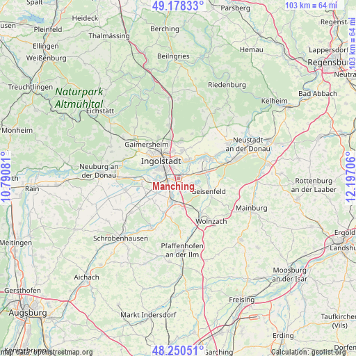
Manching GPS coordinates[2]
48° 42' 59.616" North, 11° 29' 38.148" East
| Map corner | latitude | longitude |
|---|---|---|
| Upper-left | 49.17833°, | 10.79081° |
| Center: | 48.71656°, | 11.49393° |
| Lower-right: | 48.25051°, | 12.19706° |
| Map W x H: | 103.2×103.2 km | = 64.1×64.1mi |
| max Lat: | 55.01917° ⇑86.3% North |
| Manching: | 48.71656° |
| min Lat: | ⇓13.7% South 47.40724° |
| min Long | Manching | max Long |
| 5.92978° | 11.49393° | 14.98853° |
| W 74.2%⇐ | ⇒25.8% E |
Elevation
Elevation of Manching is 368 m = 1207 ft, and this is 118.9 m = 390 ft above average elevation for this country.
| Max E: |
1256 m = 4121 ft | 28.7% |
| Manching | 368 m 1207 ft | |
| Avg. | 249.1 m = 817 ft | |
Min E: |
-5 m = -16 ft | 71.3% |
See also: Germany elevation on elevation.city.
Geographical zone
Manching is located in North temperate zone (between Tropic of Cancer and the Arctic Circle). Distance of this North polar circle is 1984.4 km =1233 mi to North.| Distance of | km | miles | from Manching |
|---|---|---|---|
| North Pole | 4590.3 | 2852.3 | to North |
| Arctic Circle | 1984.4 | 1233 | to North |
| Tropic Cancer | 2810.9 | 1746.6 | to South |
| Equator | 5416.8 | 3365.8 | to South |


Nearby cities:
15 places around Manching: (largest is in red/bold)
• Baar-Ebenhausen
5.4 km =3.4 mi,  199°
199°
• Ernsgaden
6.8 km =4.2 mi,  74°
74°
• Gaimersheim
13.7 km =8.5 mi,  317°
317°
• Geisenfeld
9.4 km =5.8 mi,  112°
112°
• Großmehring
6.3 km =3.9 mi,  27°
27°
• Hepberg
12 km =7.5 mi,  348°
348°
• Ingolstadt
7.5 km =4.7 mi, 316°
• Karlskron
6.8 km =4.2 mi,  236°
236°
• Lenting
10.7 km =6.6 mi, 346°
• Pörnbach
11.3 km =7 mi,  190°
190°
• Reichertshofen
6.9 km =4.3 mi, 197°
• Rohrbach
12.3 km =7.6 mi,  154°
154°
• Vohburg an der Donau
10.9 km =6.8 mi,  57°
57°
• Weichering
12.7 km =7.9 mi,  270°
270°
• Wettstetten
13.1 km =8.1 mi,  333°
333°
Sources, notices
• [Note1] Compared only with cities in Germany existing in our database
• [Src1] Map data: © OpenStreetMap contributors (CC-BY-SA)
• [Src2] Other city data from geonames.org with taken over terms of usage.
• [Src3] Geographical zone / Annual Mean Temperature by Robert A. Rohde @ Wikipedia
