Reichertshofen geodata
Reichertshofen (Bavaria) is a populated place; located in Germany in Europe/Berlin (GMT+2) time zone. With population of 7,298 people, there are 2119 cities with bigger population in this country. Compared to other cities in Germany, 87% of cities are located further ↑North; 73.8% of cities are located further ←West and 73.1% of cities have lower elevation than Reichertshofen. Note1
Administrative division(s):
- Level 1: Bavaria
- Level 2: Upper Bavaria
- Level 3: Landkreis Pfaffenhofen an der Ilm
- Level 4: Reichertshofen, Markt


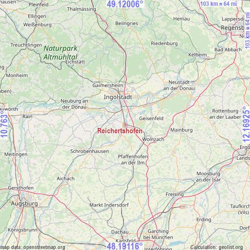
Reichertshofen GPS coordinates[2]
48° 39' 27.9" North, 11° 27' 58.032" East
| Map corner | latitude | longitude |
|---|---|---|
| Upper-left | 49.12006°, | 10.763° |
| Center: | 48.65775°, | 11.46612° |
| Lower-right: | 48.19116°, | 12.16925° |
| Map W x H: | 103.3×103.3 km | = 64.2×64.2mi |
| max Lat: | 55.01917° ⇑87% North |
| Reichertshofen: | 48.65775° |
| min Lat: | ⇓13% South 47.40724° |
| min Long | Reichertshofen | max Long |
| 5.92978° | 11.46612° | 14.98853° |
| W 73.8%⇐ | ⇒26.2% E |
Elevation
Elevation of Reichertshofen is 383 m = 1257 ft, and this is 133.9 m = 439 ft above average elevation for this country.
| Max E: |
1256 m = 4121 ft | 26.9% |
| Reichertshofen | 383 m 1257 ft | |
| Avg. | 249.1 m = 817 ft | |
Min E: |
-5 m = -16 ft | 73.1% |
See also: Germany elevation on elevation.city.
Geographical zone
Reichertshofen is located in North temperate zone (between Tropic of Cancer and the Arctic Circle). Distance of this North polar circle is 1990.9 km =1237.1 mi to North.| Distance of | km | miles | from Reichertshofen |
|---|---|---|---|
| North Pole | 4596.8 | 2856.3 | to North |
| Arctic Circle | 1990.9 | 1237.1 | to North |
| Tropic Cancer | 2804.3 | 1742.5 | to South |
| Equator | 5410.2 | 3361.7 | to South |


Nearby cities:
15 places around Reichertshofen: (largest is in red/bold)
• Baar-Ebenhausen
1.5 km =0.9 mi,  10°
10°
• Brunnen
12 km =7.5 mi,  254°
254°
• Ernsgaden
12 km =7.5 mi,  45°
45°
• Geisenfeld
11.1 km =6.9 mi,  74°
74°
• Großmehring
13.1 km =8.1 mi,  22°
22°
• Ingolstadt
12.3 km =7.6 mi,  345°
345°
• Karlshuld
13.6 km =8.5 mi,  281°
281°
• Karlskron
4.6 km =2.9 mi,  308°
308°
• Manching
6.9 km =4.3 mi, 17°
• Pfaffenhofen an der Ilm
14.4 km =8.9 mi,  168°
168°
• Pörnbach
4.6 km =2.9 mi,  179°
179°
• Rohrbach
8.7 km =5.4 mi,  121°
121°
• Waidhofen
13.2 km =8.2 mi,  226°
226°
• Weichering
12.5 km =7.8 mi,  301°
301°
• Wolnzach
13.2 km =8.2 mi, 117°
Sources, notices
• [Note1] Compared only with cities in Germany existing in our database
• [Src1] Map data: © OpenStreetMap contributors (CC-BY-SA)
• [Src2] Other city data from geonames.org with taken over terms of usage.
• [Src3] Geographical zone / Annual Mean Temperature by Robert A. Rohde @ Wikipedia
