Baar-Ebenhausen geodata
Baar-Ebenhausen (Bavaria) is a seat of a fourth-order administrative division; located in Germany in Europe/Berlin (GMT+2) time zone. With population of 4,862 people, there are 2879 cities with bigger population in this country. Compared to other cities in Germany, 86.9% of cities are located further ↑North; 73.8% of cities are located further ←West and 72.4% of cities have lower elevation than Baar-Ebenhausen. Note1
Administrative division(s):
- Level 1: Bavaria
- Level 2: Upper Bavaria
- Level 3: Landkreis Pfaffenhofen an der Ilm
- Level 4: Baar-Ebenhausen


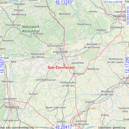
Baar-Ebenhausen GPS coordinates[2]
48° 40' 14.34" North, 11° 28' 11.388" East
| Map corner | latitude | longitude |
|---|---|---|
| Upper-left | 49.13285°, | 10.76671° |
| Center: | 48.67065°, | 11.46983° |
| Lower-right: | 48.20417°, | 12.17296° |
| Map W x H: | 103.3×103.3 km | = 64.2×64.2mi |
| max Lat: | 55.01917° ⇑86.9% North |
| Baar-Ebenhausen: | 48.67065° |
| min Lat: | ⇓13.1% South 47.40724° |
| min Long | Baar-Ebenhausen | max Long |
| 5.92978° | 11.46983° | 14.98853° |
| W 73.8%⇐ | ⇒26.2% E |
Elevation
Elevation of Baar-Ebenhausen is 377 m = 1237 ft, and this is 127.9 m = 420 ft above average elevation for this country.
| Max E: |
1256 m = 4121 ft | 27.6% |
| Baar-Ebenhausen | 377 m 1237 ft | |
| Avg. | 249.1 m = 817 ft | |
Min E: |
-5 m = -16 ft | 72.4% |
See also: Germany elevation on elevation.city.
Geographical zone
Baar-Ebenhausen is located in North temperate zone (between Tropic of Cancer and the Arctic Circle). Distance of this North polar circle is 1989.5 km =1236.2 mi to North.| Distance of | km | miles | from Baar-Ebenhausen |
|---|---|---|---|
| North Pole | 4595.4 | 2855.4 | to North |
| Arctic Circle | 1989.5 | 1236.2 | to North |
| Tropic Cancer | 2805.8 | 1743.4 | to South |
| Equator | 5411.7 | 3362.7 | to South |


Nearby cities:
15 places around Baar-Ebenhausen: (largest is in red/bold)
• Brunnen
12.7 km =7.9 mi,  248°
248°
• Ernsgaden
10.9 km =6.8 mi,  50°
50°
• Geisenfeld
10.6 km =6.6 mi,  81°
81°
• Großmehring
11.6 km =7.2 mi,  23°
23°
• Ingolstadt
11 km =6.8 mi,  342°
342°
• Karlshuld
13.6 km =8.5 mi,  275°
275°
• Karlskron
4.1 km =2.5 mi,  289°
289°
• Manching
5.4 km =3.4 mi, 19°
• Pörnbach
6 km =3.7 mi,  182°
182°
• Reichertshofen
1.5 km =0.9 mi,  190°
190°
• Rohrbach
9.3 km =5.8 mi,  130°
130°
• Vohburg an der Donau
15.5 km =9.6 mi,  44°
44°
• Waidhofen
14.4 km =8.9 mi,  223°
223°
• Weichering
12.1 km =7.5 mi,  295°
295°
• Wolnzach
13.7 km =8.5 mi,  122°
122°
Sources, notices
• [Note1] Compared only with cities in Germany existing in our database
• [Src1] Map data: © OpenStreetMap contributors (CC-BY-SA)
• [Src2] Other city data from geonames.org with taken over terms of usage.
• [Src3] Geographical zone / Annual Mean Temperature by Robert A. Rohde @ Wikipedia
