Malgersdorf geodata
Malgersdorf (Bavaria) is a seat of a fourth-order administrative division; located in Germany in Europe/Berlin (GMT+2) time zone. With population of 1,198 people, there are 6569 cities with bigger population in this country. Compared to other cities in Germany, 88.7% of cities are located further ↑North; 90.3% of cities are located further ←West and 74.9% of cities have lower elevation than Malgersdorf. Note1
Administrative division(s):
- Level 1: Bavaria
- Level 2: Lower Bavaria
- Level 3: Landkreis Rottal-Inn
- Level 4: Malgersdorf


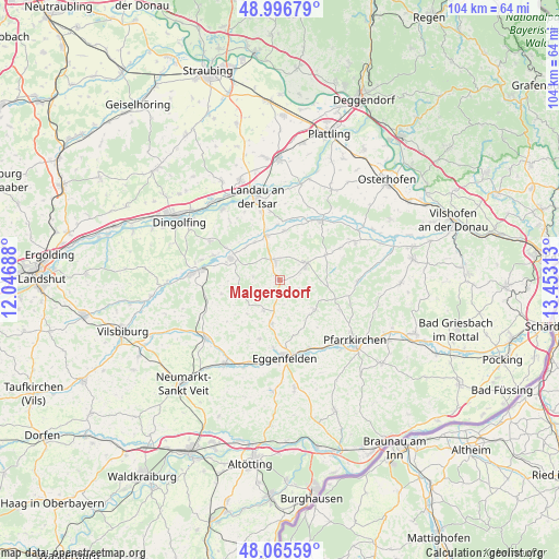
Malgersdorf GPS coordinates[2]
48° 31' 59.988" North, 12° 45' 0" East
| Map corner | latitude | longitude |
|---|---|---|
| Upper-left | 48.99679°, | 12.04688° |
| Center: | 48.53333°, | 12.75° |
| Lower-right: | 48.06559°, | 13.45313° |
| Map W x H: | 103.5×103.5 km | = 64.3×64.3mi |
| max Lat: | 55.01917° ⇑88.7% North |
| Malgersdorf: | 48.53333° |
| min Lat: | ⇓11.3% South 47.40724° |
| min Long | Malgersdorf | max Long |
| 5.92978° | 12.75° | 14.98853° |
| W 90.3%⇐ | ⇒9.7% E |
Elevation
Elevation of Malgersdorf is 397 m = 1302 ft, and this is 147.9 m = 485 ft above average elevation for this country.
| Max E: |
1256 m = 4121 ft | 25.1% |
| Malgersdorf | 397 m 1302 ft | |
| Avg. | 249.1 m = 817 ft | |
Min E: |
-5 m = -16 ft | 74.9% |
See also: Germany elevation on elevation.city.
Geographical zone
Malgersdorf is located in North temperate zone (between Tropic of Cancer and the Arctic Circle). Distance of this North polar circle is 2004.8 km =1245.7 mi to North.| Distance of | km | miles | from Malgersdorf |
|---|---|---|---|
| North Pole | 4610.7 | 2865 | to North |
| Arctic Circle | 2004.8 | 1245.7 | to North |
| Tropic Cancer | 2790.5 | 1733.9 | to South |
| Equator | 5396.4 | 3353.2 | to South |


Nearby cities:
15 places around Malgersdorf: (largest is in red/bold)
• Arnstorf
5.6 km =3.5 mi,  60°
60°
• Dietersburg
13.7 km =8.5 mi,  109°
109°
• Eggenfelden
14.3 km =8.9 mi,  177°
177°
• Eichendorf
13.5 km =8.4 mi,  35°
35°
• Falkenberg
8.1 km =5 mi,  190°
190°
• Hebertsfelden
15.1 km =9.4 mi,  159°
159°
• Johanniskirchen
14.7 km =9.1 mi,  90°
90°
• Marklkofen
13.6 km =8.5 mi,  277°
277°
• Reisbach
9.9 km =6.2 mi,  294°
294°
• Rimbach
10.5 km =6.5 mi,  224°
224°
• Rossbach
15.7 km =9.8 mi,  69°
69°
• Roßbach
15.4 km =9.6 mi, 61°
• Ruhstorf
5 km =3.1 mi, 278°
• Schönau
9.2 km =5.7 mi,  127°
127°
• Simbach
3.7 km =2.3 mi,  347°
347°
Sources, notices
• [Note1] Compared only with cities in Germany existing in our database
• [Src1] Map data: © OpenStreetMap contributors (CC-BY-SA)
• [Src2] Other city data from geonames.org with taken over terms of usage.
• [Src3] Geographical zone / Annual Mean Temperature by Robert A. Rohde @ Wikipedia
