Hameln geodata
Hameln (Lower Saxony) is a seat of a third-order administrative division; located in Germany in Europe/Berlin (GMT+2) time zone. With population of 58,666 people, there are 181 cities with bigger population in this country. Compared to other cities in Germany, 73% of cities are located further ↓South; 60% of cities are located further →East and 72.6% of cities have higher elevation than Hameln. Note1


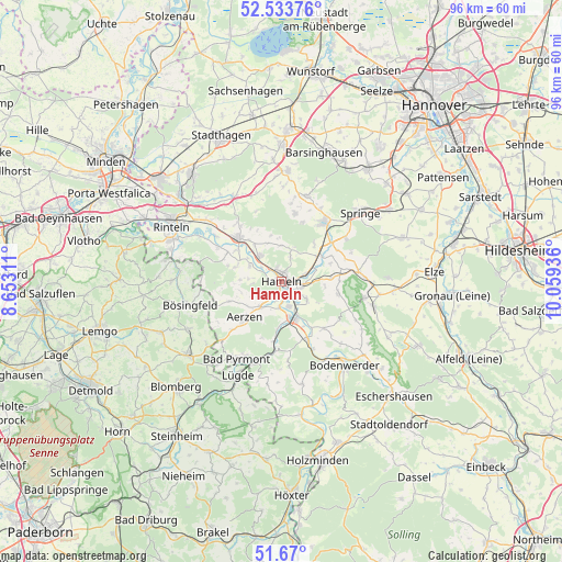
Hameln GPS coordinates[2]
52° 6' 14.292" North, 9° 21' 22.428" East
| Map corner | latitude | longitude |
|---|---|---|
| Upper-left | 52.53376°, | 8.65311° |
| Center: | 52.10397°, | 9.35623° |
| Lower-right: | 51.67°, | 10.05936° |
| Map W x H: | 96×96 km | = 59.7×59.7mi |
| max Lat: | 55.01917° ⇑27% North |
| Hameln: | 52.10397° |
| min Lat: | ⇓73% South 47.40724° |
| min Long | Hameln | max Long |
| 5.92978° | 9.35623° | 14.98853° |
| W 40%⇐ | ⇒60% E |
Elevation
Elevation of Hameln is 74 m = 243 ft, and this is 175.1 m = 574 ft below average elevation for this country.
| Max E: |
1256 m = 4121 ft | 72.6% |
| Avg. | 249.1 m = 817 ft | |
| Hameln | 74 m = 243 ft | |
Min E: |
-5 m = -16 ft | 27.4% |
See also: Hameln elevation on elevation.city.
Geographical zone
Hameln is located in North temperate zone (between Tropic of Cancer and the Arctic Circle). Distance of this North polar circle is 1607.8 km =999 mi to North.| Distance of | km | miles | from Hameln |
|---|---|---|---|
| North Pole | 4213.6 | 2618.2 | to North |
| Arctic Circle | 1607.8 | 999 | to North |
| Tropic Cancer | 3187.5 | 1980.6 | to South |
| Equator | 5793.4 | 3599.9 | to South |


Nearby cities:
15 places around Hameln: (largest is in red/bold)
• Aerzen
9 km =5.6 mi,  227°
227°
• Bad Münder am Deister
12.6 km =7.8 mi,  35°
35°
• Bad Pyrmont
14.9 km =9.3 mi,  208°
208°
• Coppenbrügge
13.2 km =8.2 mi,  82°
82°
• Hehlen
15 km =9.3 mi,  148°
148°
• Hessisch Oldendorf
10.6 km =6.6 mi,  316°
316°
• Heyen
14.6 km =9.1 mi,  136°
136°
• Hülsede
16.2 km =10.1 mi,  1°
1°
• Lügde
17.8 km =11.1 mi,  204°
204°
• Messenkamp
17.4 km =10.8 mi,  5°
5°
• Ottenstein
17.8 km =11.1 mi,  168°
168°
• Pohle
18.1 km =11.2 mi,  357°
357°
• Rehren
16.6 km =10.3 mi,  329°
329°
• Salzhemmendorf
16.3 km =10.1 mi,  104°
104°
• Springe
17.8 km =11.1 mi,  49°
49°
In other languages:
- In Spanish: Hamelín
- In France: Hamelin
- In Italian: Hamelin
- In Russian: Хамельн
- In Chinese: 哈默爾恩
Sources, notices
• [Note1] Compared only with cities in Germany existing in our database
• [Src1] Map data: © OpenStreetMap contributors (CC-BY-SA)
• [Src2] Other city data from geonames.org with taken over terms of usage.
• [Src3] Geographical zone / Annual Mean Temperature by Robert A. Rohde @ Wikipedia
