Aerzen geodata
Aerzen (Lower Saxony) is a seat of a fourth-order administrative division; located in Germany in Europe/Berlin (GMT+2) time zone. With population of 10,755 people, there are 1537 cities with bigger population in this country. Compared to other cities in Germany, 72.5% of cities are located further ↓South; 61.4% of cities are located further →East and 67.4% of cities have higher elevation than Aerzen. Note1
Administrative division(s):
- Level 1: Lower Saxony
- Level 3: Landkreis Hameln-Pyrmont
- Level 4: Aerzen, Flecken


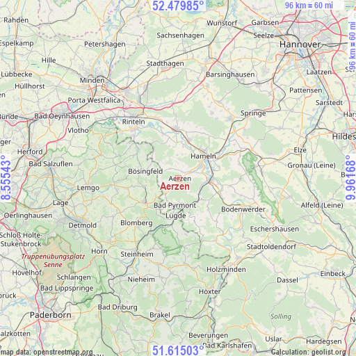
Aerzen GPS coordinates[2]
52° 2' 58.308" North, 9° 15' 30.816" East
| Map corner | latitude | longitude |
|---|---|---|
| Upper-left | 52.47985°, | 8.55543° |
| Center: | 52.04953°, | 9.25856° |
| Lower-right: | 51.61503°, | 9.96168° |
| Map W x H: | 96.2×96.2 km | = 59.8×59.8mi |
| max Lat: | 55.01917° ⇑27.5% North |
| Aerzen: | 52.04953° |
| min Lat: | ⇓72.5% South 47.40724° |
| min Long | Aerzen | max Long |
| 5.92978° | 9.25856° | 14.98853° |
| W 38.6%⇐ | ⇒61.4% E |
Elevation
Elevation of Aerzen is 105 m = 344 ft, and this is 144.1 m = 473 ft below average elevation for this country.
| Max E: |
1256 m = 4121 ft | 67.4% |
| Avg. | 249.1 m = 817 ft | |
| Aerzen | 105 m = 344 ft | |
Min E: |
-5 m = -16 ft | 32.6% |
See also: Germany elevation on elevation.city.
Geographical zone
Aerzen is located in North temperate zone (between Tropic of Cancer and the Arctic Circle). Distance of this North polar circle is 1613.8 km =1002.8 mi to North.| Distance of | km | miles | from Aerzen |
|---|---|---|---|
| North Pole | 4219.7 | 2622 | to North |
| Arctic Circle | 1613.8 | 1002.8 | to North |
| Tropic Cancer | 3181.4 | 1976.8 | to South |
| Equator | 5787.4 | 3596.1 | to South |


Nearby cities:
15 places around Aerzen: (largest is in red/bold)
• Bad Pyrmont
7.1 km =4.4 mi,  183°
183°
• Barntrup
11.7 km =7.3 mi,  235°
235°
• Blomberg
16.5 km =10.3 mi,  224°
224°
• Brevörde
18.3 km =11.4 mi,  143°
143°
• Dörentrup
17.5 km =10.9 mi,  266°
266°
• Hameln
9 km =5.6 mi,  47°
47°
• Hehlen
16 km =9.9 mi,  115°
115°
• Hessisch Oldendorf
13.7 km =8.5 mi,  357°
357°
• Heyen
17.3 km =10.7 mi,  104°
104°
• Lügde
10.2 km =6.3 mi, 184°
• Ottenstein
15.3 km =9.5 mi, 138°
• Polle
19.5 km =12.1 mi,  149°
149°
• Rinteln
19.5 km =12.1 mi,  321°
321°
• Schieder-Schwalenberg
19.7 km =12.2 mi,  192°
192°
• Vahlbruch
15.4 km =9.6 mi,  158°
158°
Sources, notices
• [Note1] Compared only with cities in Germany existing in our database
• [Src1] Map data: © OpenStreetMap contributors (CC-BY-SA)
• [Src2] Other city data from geonames.org with taken over terms of usage.
• [Src3] Geographical zone / Annual Mean Temperature by Robert A. Rohde @ Wikipedia
