Jüterbog geodata
Jüterbog (Brandenburg) is a populated place; located in Germany in Europe/Berlin (GMT+2) time zone. With population of 13,292 people, there are 1204 cities with bigger population in this country. Compared to other cities in Germany, 72.2% of cities are located further ↓South; 92.8% of cities are located further ←West and 73% of cities have higher elevation than Jüterbog. Note1
Administrative division(s):
- Level 1: Brandenburg
- Level 3: Landkreis Teltow-Fläming
- Level 4: Jüterbog


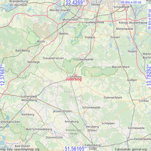
Jüterbog GPS coordinates[2]
51° 59' 45.852" North, 13° 4' 47.244" East
| Map corner | latitude | longitude |
|---|---|---|
| Upper-left | 52.4269°, | 12.37667° |
| Center: | 51.99607°, | 13.07979° |
| Lower-right: | 51.56105°, | 13.78292° |
| Map W x H: | 96.3×96.3 km | = 59.8×59.8mi |
| max Lat: | 55.01917° ⇑27.8% North |
| Jüterbog: | 51.99607° |
| min Lat: | ⇓72.2% South 47.40724° |
| min Long | Jüterbog | max Long |
| 5.92978° | 13.07979° | 14.98853° |
| W 92.8%⇐ | ⇒7.2% E |
Elevation
Elevation of Jüterbog is 72 m = 236 ft, and this is 177.1 m = 581 ft below average elevation for this country.
| Max E: |
1256 m = 4121 ft | 73% |
| Avg. | 249.1 m = 817 ft | |
| Jüterbog | 72 m = 236 ft | |
Min E: |
-5 m = -16 ft | 27% |
See also: Germany elevation on elevation.city.
Geographical zone
Jüterbog is located in North temperate zone (between Tropic of Cancer and the Arctic Circle). Distance of this North polar circle is 1619.8 km =1006.5 mi to North.| Distance of | km | miles | from Jüterbog |
|---|---|---|---|
| North Pole | 4225.6 | 2625.7 | to North |
| Arctic Circle | 1619.8 | 1006.5 | to North |
| Tropic Cancer | 3175.5 | 1973.2 | to South |
| Equator | 5781.4 | 3592.4 | to South |


Nearby cities:
15 places around Jüterbog: (largest is in red/bold)
• Bülzig
25 km =15.5 mi,  242°
242°
• Elster
25.5 km =15.8 mi,  223°
223°
• Holzdorf
24.4 km =15.2 mi,  172°
172°
• Ihlow
22.8 km =14.2 mi,  129°
129°
• Jessen
24 km =14.9 mi,  200°
200°
• Kropstädt
23.2 km =14.4 mi,  260°
260°
• Linda
15.6 km =9.7 mi, 174°
• Luckenwalde
12.1 km =7.5 mi,  29°
29°
• Niedergörsdorf
6.7 km =4.2 mi,  254°
254°
• Seyda
17.3 km =10.7 mi, 222°
• Sperenberg
25.3 km =15.7 mi,  50°
50°
• Trebbin
26.5 km =16.5 mi,  22°
22°
• Treuenbrietzen
18.1 km =11.2 mi,  308°
308°
• Zahna
22.1 km =13.7 mi, 245°
• Zörnigall
26.3 km =16.3 mi, 237°
Sources, notices
• [Note1] Compared only with cities in Germany existing in our database
• [Src1] Map data: © OpenStreetMap contributors (CC-BY-SA)
• [Src2] Other city data from geonames.org with taken over terms of usage.
• [Src3] Geographical zone / Annual Mean Temperature by Robert A. Rohde @ Wikipedia
