Insel geodata
Insel (Saxony-Anhalt) is a populated place; located in Germany in Europe/Berlin (GMT+2) time zone. With population of 759 people, there are 8052 cities with bigger population in this country. Compared to other cities in Germany, 78.2% of cities are located further ↓South; 78.1% of cities are located further ←West and 81% of cities have higher elevation than Insel. Note1


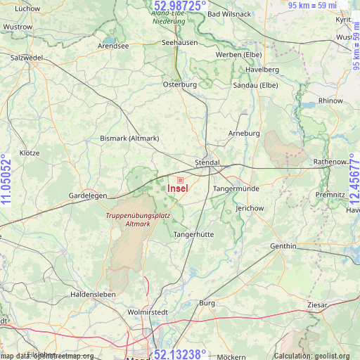
Insel GPS coordinates[2]
52° 33' 42.84" North, 11° 45' 13.104" East
| Map corner | latitude | longitude |
|---|---|---|
| Upper-left | 52.98725°, | 11.05052° |
| Center: | 52.5619°, | 11.75364° |
| Lower-right: | 52.13238°, | 12.45677° |
| Map W x H: | 95.1×95.1 km | = 59.1×59.1mi |
| max Lat: | 55.01917° ⇑21.8% North |
| Insel: | 52.5619° |
| min Lat: | ⇓78.2% South 47.40724° |
| min Long | Insel | max Long |
| 5.92978° | 11.75364° | 14.98853° |
| W 78.1%⇐ | ⇒21.9% E |
Elevation
Elevation of Insel is 44 m = 144 ft, and this is 205.1 m = 673 ft below average elevation for this country.
| Max E: |
1256 m = 4121 ft | 81% |
| Avg. | 249.1 m = 817 ft | |
| Insel | 44 m = 144 ft | |
Min E: |
-5 m = -16 ft | 19% |
See also: Germany elevation on elevation.city.
Geographical zone
Insel is located in North temperate zone (between Tropic of Cancer and the Arctic Circle). Distance of this North polar circle is 1556.8 km =967.4 mi to North.| Distance of | km | miles | from Insel |
|---|---|---|---|
| North Pole | 4162.7 | 2586.6 | to North |
| Arctic Circle | 1556.8 | 967.4 | to North |
| Tropic Cancer | 3238.4 | 2012.2 | to South |
| Equator | 5844.3 | 3631.5 | to South |


Nearby cities:
15 places around Insel: (largest is in red/bold)
• Badingen
9.2 km =5.7 mi,  304°
304°
• Dahlen
4.9 km =3 mi,  91°
91°
• Hassel
14.5 km =9 mi,  53°
53°
• Heeren
9.2 km =5.7 mi,  103°
103°
• Jarchau
14.1 km =8.8 mi,  42°
42°
• Kläden
10 km =6.2 mi,  321°
321°
• Lindstedt
15.4 km =9.6 mi,  282°
282°
• Lüderitz
5.9 km =3.7 mi,  186°
186°
• Möringen
3.3 km =2.1 mi,  350°
350°
• Rochau
16.2 km =10.1 mi,  357°
357°
• Stendal
8.7 km =5.4 mi, 54°
• Tangerhütte
14.5 km =9 mi,  165°
165°
• Tangermünde
15.2 km =9.4 mi, 97°
• Uchtspringe
10.7 km =6.6 mi,  256°
256°
• Uenglingen
7.3 km =4.5 mi,  30°
30°
Sources, notices
• [Note1] Compared only with cities in Germany existing in our database
• [Src1] Map data: © OpenStreetMap contributors (CC-BY-SA)
• [Src2] Other city data from geonames.org with taken over terms of usage.
• [Src3] Geographical zone / Annual Mean Temperature by Robert A. Rohde @ Wikipedia
