Lengede geodata
Lengede (Lower Saxony) is a seat of a fourth-order administrative division; located in Germany in Europe/Berlin (GMT+2) time zone. With population of 12,993 people, there are 1238 cities with bigger population in this country. Compared to other cities in Germany, 74.1% of cities are located further ↓South; 55.5% of cities are located further ←West and 71.3% of cities have higher elevation than Lengede. Note1


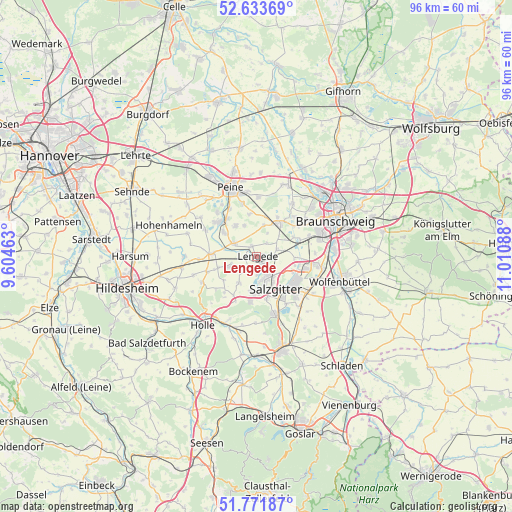
Lengede GPS coordinates[2]
52° 12' 17.532" North, 10° 18' 27.9" East
| Map corner | latitude | longitude |
|---|---|---|
| Upper-left | 52.63369°, | 9.60463° |
| Center: | 52.20487°, | 10.30775° |
| Lower-right: | 51.77187°, | 11.01088° |
| Map W x H: | 95.8×95.8 km | = 59.5×59.5mi |
| max Lat: | 55.01917° ⇑25.9% North |
| Lengede: | 52.20487° |
| min Lat: | ⇓74.1% South 47.40724° |
| min Long | Lengede | max Long |
| 5.92978° | 10.30775° | 14.98853° |
| W 55.5%⇐ | ⇒44.5% E |
Elevation
Elevation of Lengede is 82 m = 269 ft, and this is 167.1 m = 548 ft below average elevation for this country.
| Max E: |
1256 m = 4121 ft | 71.3% |
| Avg. | 249.1 m = 817 ft | |
| Lengede | 82 m = 269 ft | |
Min E: |
-5 m = -16 ft | 28.7% |
See also: Germany elevation on elevation.city.
Geographical zone
Lengede is located in North temperate zone (between Tropic of Cancer and the Arctic Circle). Distance of this North polar circle is 1596.5 km =992 mi to North.| Distance of | km | miles | from Lengede |
|---|---|---|---|
| North Pole | 4202.4 | 2611.2 | to North |
| Arctic Circle | 1596.5 | 992 | to North |
| Tropic Cancer | 3198.7 | 1987.6 | to South |
| Equator | 5804.6 | 3606.8 | to South |


Nearby cities:
15 places around Lengede: (largest is in red/bold)
• Baddeckenstedt
14.4 km =8.9 mi,  200°
200°
• Braunschweig
16.4 km =10.2 mi,  65°
65°
• Burgdorf
9.1 km =5.7 mi,  222°
222°
• Cramme
13.9 km =8.6 mi,  137°
137°
• Elbe
13.6 km =8.5 mi,  187°
187°
• Heere
15.9 km =9.9 mi, 194°
• Ilsede
9.8 km =6.1 mi,  311°
311°
• Leiferde
13.7 km =8.5 mi,  90°
90°
• Meerdorf
15.7 km =9.8 mi,  2°
2°
• Peine
13.6 km =8.5 mi,  338°
338°
• Salzgitter
9.1 km =5.7 mi,  125°
125°
• Schellerten
14.2 km =8.8 mi,  261°
261°
• Söhlde
5.4 km =3.4 mi,  251°
251°
• Vechelde
7.3 km =4.5 mi,  32°
32°
• Wendeburg
15 km =9.3 mi,  22°
22°
Sources, notices
• [Note1] Compared only with cities in Germany existing in our database
• [Src1] Map data: © OpenStreetMap contributors (CC-BY-SA)
• [Src2] Other city data from geonames.org with taken over terms of usage.
• [Src3] Geographical zone / Annual Mean Temperature by Robert A. Rohde @ Wikipedia
