Ilsede geodata
Ilsede (Lower Saxony) is a seat of a fourth-order administrative division; located in Germany in Europe/Berlin (GMT+2) time zone. With population of 12,241 people, there are 1337 cities with bigger population in this country. Compared to other cities in Germany, 74.8% of cities are located further ↓South; 53.3% of cities are located further ←West and 72.6% of cities have higher elevation than Ilsede. Note1


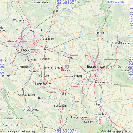
Ilsede GPS coordinates[2]
52° 15' 48.24" North, 10° 11' 57.192" East
| Map corner | latitude | longitude |
|---|---|---|
| Upper-left | 52.69165°, | 9.4961° |
| Center: | 52.2634°, | 10.19922° |
| Lower-right: | 51.83097°, | 10.90235° |
| Map W x H: | 95.7×95.7 km | = 59.5×59.5mi |
| max Lat: | 55.01917° ⇑25.2% North |
| Ilsede: | 52.2634° |
| min Lat: | ⇓74.8% South 47.40724° |
| min Long | Ilsede | max Long |
| 5.92978° | 10.19922° | 14.98853° |
| W 53.3%⇐ | ⇒46.7% E |
Elevation
Elevation of Ilsede is 74 m = 243 ft, and this is 175.1 m = 574 ft below average elevation for this country.
| Max E: |
1256 m = 4121 ft | 72.6% |
| Avg. | 249.1 m = 817 ft | |
| Ilsede | 74 m = 243 ft | |
Min E: |
-5 m = -16 ft | 27.4% |
See also: Germany elevation on elevation.city.
Geographical zone
Ilsede is located in North temperate zone (between Tropic of Cancer and the Arctic Circle). Distance of this North polar circle is 1590 km =988 mi to North.| Distance of | km | miles | from Ilsede |
|---|---|---|---|
| North Pole | 4195.9 | 2607.2 | to North |
| Arctic Circle | 1590 | 988 | to North |
| Tropic Cancer | 3205.2 | 1991.6 | to South |
| Equator | 5811.1 | 3610.8 | to South |


Nearby cities:
15 places around Ilsede: (largest is in red/bold)
• Algermissen
15.7 km =9.8 mi,  265°
265°
• Arpke
15.2 km =9.4 mi,  333°
333°
• Burgdorf
13.3 km =8.3 mi,  174°
174°
• Dollbergen
16 km =9.9 mi,  355°
355°
• Edemissen
14.4 km =8.9 mi,  17°
17°
• Harsum
17 km =10.6 mi,  249°
249°
• Hohenhameln
9.2 km =5.7 mi, 265°
• Lengede
9.8 km =6.1 mi,  131°
131°
• Meerdorf
12.2 km =7.6 mi,  41°
41°
• Peine
6.7 km =4.2 mi, 21°
• Schellerten
10.9 km =6.8 mi,  217°
217°
• Sehnde
16.7 km =10.4 mi,  289°
289°
• Söhlde
8.6 km =5.3 mi,  164°
164°
• Vechelde
11.3 km =7 mi,  91°
91°
• Wendeburg
15.1 km =9.4 mi,  60°
60°
Sources, notices
• [Note1] Compared only with cities in Germany existing in our database
• [Src1] Map data: © OpenStreetMap contributors (CC-BY-SA)
• [Src2] Other city data from geonames.org with taken over terms of usage.
• [Src3] Geographical zone / Annual Mean Temperature by Robert A. Rohde @ Wikipedia
