Burgdorf geodata
Burgdorf (Lower Saxony) is a populated place; located in Germany in Europe/Berlin (GMT+2) time zone. With population of 30,218 people, there are 461 cities with bigger population in this country. Compared to other cities in Germany, 76.8% of cities are located further ↓South; 50.2% of cities are located further ←West and 77.3% of cities have higher elevation than Burgdorf. Note1


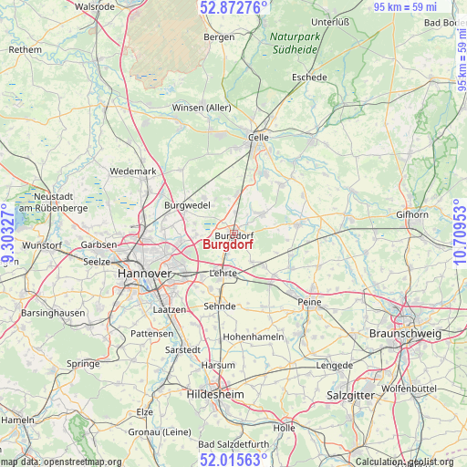
Burgdorf GPS coordinates[2]
52° 26' 46.608" North, 10° 0' 23.04" East
| Map corner | latitude | longitude |
|---|---|---|
| Upper-left | 52.87276°, | 9.30327° |
| Center: | 52.44628°, | 10.0064° |
| Lower-right: | 52.01563°, | 10.70953° |
| Map W x H: | 95.3×95.3 km | = 59.2×59.2mi |
| max Lat: | 55.01917° ⇑23.2% North |
| Burgdorf: | 52.44628° |
| min Lat: | ⇓76.8% South 47.40724° |
| min Long | Burgdorf | max Long |
| 5.92978° | 10.0064° | 14.98853° |
| W 50.2%⇐ | ⇒49.8% E |
Elevation
Elevation of Burgdorf is 55 m = 180 ft, and this is 194.1 m = 637 ft below average elevation for this country.
| Max E: |
1256 m = 4121 ft | 77.3% |
| Avg. | 249.1 m = 817 ft | |
| Burgdorf | 55 m = 180 ft | |
Min E: |
-5 m = -16 ft | 22.7% |
See also: Germany elevation on elevation.city.
Geographical zone
Burgdorf is located in North temperate zone (between Tropic of Cancer and the Arctic Circle). Distance of this North polar circle is 1569.7 km =975.4 mi to North.| Distance of | km | miles | from Burgdorf |
|---|---|---|---|
| North Pole | 4175.6 | 2594.6 | to North |
| Arctic Circle | 1569.7 | 975.4 | to North |
| Tropic Cancer | 3225.6 | 2004.3 | to South |
| Equator | 5831.5 | 3623.5 | to South |


Nearby cities:
15 places around Burgdorf: (largest is in red/bold)
• Adelheidsdorf
13.6 km =8.5 mi,  15°
15°
• Altmerdingsen
8.6 km =5.3 mi,  76°
76°
• Arpke
9.3 km =5.8 mi,  136°
136°
• Bröckel
16.1 km =10 mi,  61°
61°
• Dollbergen
12.6 km =7.8 mi,  110°
110°
• Eicklingen
16.7 km =10.4 mi,  46°
46°
• Hänigsen
7.1 km =4.4 mi, 53°
• Isernhagen Farster Bauerschaft
11.5 km =7.1 mi,  283°
283°
• Lehrte
8.5 km =5.3 mi,  192°
192°
• Nienhagen
13.9 km =8.6 mi,  27°
27°
• Schwüblingsen
9.6 km =6 mi, 113°
• Sehnde
14.9 km =9.3 mi, 189°
• Uetze
13.6 km =8.5 mi, 81°
• Wathlingen
14 km =8.7 mi,  44°
44°
• Wehnsen
17.6 km =10.9 mi,  97°
97°
In other languages:
- In German: Burgdorf (Region Hannover), Burgtorff [a. 1654], Borgtorff [a. 1654], Burgdorf
- In Russian: Бургдорф (Ганновер)
Sources, notices
• [Note1] Compared only with cities in Germany existing in our database
• [Src1] Map data: © OpenStreetMap contributors (CC-BY-SA)
• [Src2] Other city data from geonames.org with taken over terms of usage.
• [Src3] Geographical zone / Annual Mean Temperature by Robert A. Rohde @ Wikipedia
