Lehrte geodata
Lehrte (Lower Saxony) is a seat of a fourth-order administrative division; located in Germany in Europe/Berlin (GMT+2) time zone. With population of 43,920 people, there are 272 cities with bigger population in this country. Compared to other cities in Germany, 75.9% of cities are located further ↓South; 50.4% of cities are located further →East and 75.8% of cities have higher elevation than Lehrte. Note1


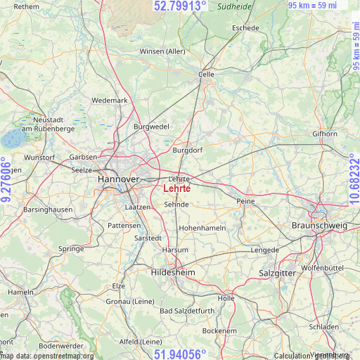
Lehrte GPS coordinates[2]
52° 22' 18.948" North, 9° 58' 45.084" East
| Map corner | latitude | longitude |
|---|---|---|
| Upper-left | 52.79913°, | 9.27606° |
| Center: | 52.37193°, | 9.97919° |
| Lower-right: | 51.94056°, | 10.68232° |
| Map W x H: | 95.5×95.5 km | = 59.3×59.3mi |
| max Lat: | 55.01917° ⇑24.1% North |
| Lehrte: | 52.37193° |
| min Lat: | ⇓75.9% South 47.40724° |
| min Long | Lehrte | max Long |
| 5.92978° | 9.97919° | 14.98853° |
| W 49.6%⇐ | ⇒50.4% E |
Elevation
Elevation of Lehrte is 60 m = 197 ft, and this is 189.1 m = 620 ft below average elevation for this country.
| Max E: |
1256 m = 4121 ft | 75.8% |
| Avg. | 249.1 m = 817 ft | |
| Lehrte | 60 m = 197 ft | |
Min E: |
-5 m = -16 ft | 24.2% |
See also: Lehrte elevation on elevation.city.
Geographical zone
Lehrte is located in North temperate zone (between Tropic of Cancer and the Arctic Circle). Distance of this North polar circle is 1578 km =980.5 mi to North.| Distance of | km | miles | from Lehrte |
|---|---|---|---|
| North Pole | 4183.8 | 2599.7 | to North |
| Arctic Circle | 1578 | 980.5 | to North |
| Tropic Cancer | 3217.3 | 1999.1 | to South |
| Equator | 5823.2 | 3618.4 | to South |


Nearby cities:
15 places around Lehrte: (largest is in red/bold)
• Algermissen
13.2 km =8.2 mi,  182°
182°
• Altmerdingsen
14.5 km =9 mi,  44°
44°
• Arpke
8.4 km =5.2 mi,  79°
79°
• Burgdorf
8.5 km =5.3 mi,  12°
12°
• Dollbergen
14.2 km =8.8 mi,  74°
74°
• Hannover
16.7 km =10.4 mi,  269°
269°
• Harsum
18 km =11.2 mi, 183°
• Hohenhameln
14 km =8.7 mi,  155°
155°
• Hänigsen
14.6 km =9.1 mi,  31°
31°
• Isernhagen Farster Bauerschaft
14.4 km =8.9 mi,  319°
319°
• Laatzen
13.9 km =8.6 mi,  242°
242°
• Peine
18.3 km =11.4 mi,  108°
108°
• Sarstedt
17.4 km =10.8 mi,  209°
209°
• Schwüblingsen
11.6 km =7.2 mi, 67°
• Sehnde
6.5 km =4 mi,  186°
186°
Sources, notices
• [Note1] Compared only with cities in Germany existing in our database
• [Src1] Map data: © OpenStreetMap contributors (CC-BY-SA)
• [Src2] Other city data from geonames.org with taken over terms of usage.
• [Src3] Geographical zone / Annual Mean Temperature by Robert A. Rohde @ Wikipedia
