Schernfeld geodata
Schernfeld (Bavaria) is a seat of a fourth-order administrative division; located in Germany in Europe/Berlin (GMT+2) time zone. In our database, there are 11009 cities with bigger population. Compared to other cities in Germany, 84.1% of cities are located further ↑North; 68.4% of cities are located further ←West and 89.6% of cities have lower elevation than Schernfeld. Note1
Administrative division(s):
- Level 1: Bavaria
- Level 2: Upper Bavaria
- Level 3: Landkreis Eichstätt
- Level 4: Schernfeld


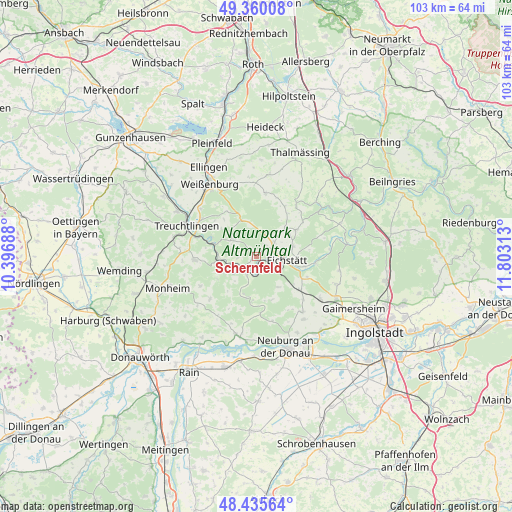
Schernfeld GPS coordinates[2]
48° 54' 0" North, 11° 6' 0" East
| Map corner | latitude | longitude |
|---|---|---|
| Upper-left | 49.36008°, | 10.39688° |
| Center: | 48.9°, | 11.1° |
| Lower-right: | 48.43564°, | 11.80313° |
| Map W x H: | 102.8×102.8 km | = 63.9×63.9mi |
| max Lat: | 55.01917° ⇑84.1% North |
| Schernfeld: | 48.9° |
| min Lat: | ⇓15.9% South 47.40724° |
| min Long | Schernfeld | max Long |
| 5.92978° | 11.1° | 14.98853° |
| W 68.4%⇐ | ⇒31.6% E |
Elevation
Elevation of Schernfeld is 509 m = 1670 ft, and this is 259.9 m = 853 ft above average elevation for this country.
| Max E: |
1256 m = 4121 ft | 10.4% |
| Schernfeld | 509 m 1670 ft | |
| Avg. | 249.1 m = 817 ft | |
Min E: |
-5 m = -16 ft | 89.6% |
See also: Germany elevation on elevation.city.
Geographical zone
Schernfeld is located in North temperate zone (between Tropic of Cancer and the Arctic Circle). Distance of this North polar circle is 1964 km =1220.4 mi to North.| Distance of | km | miles | from Schernfeld |
|---|---|---|---|
| North Pole | 4569.9 | 2839.6 | to North |
| Arctic Circle | 1964 | 1220.4 | to North |
| Tropic Cancer | 2831.3 | 1759.3 | to South |
| Equator | 5437.2 | 3378.5 | to South |


Nearby cities:
15 places around Schernfeld: (largest is in red/bold)
• Adelschlag
11 km =6.8 mi,  127°
127°
• Burgsalach
14.8 km =9.2 mi,  359°
359°
• Egweil
16.2 km =10.1 mi,  143°
143°
• Eichstätt
7.2 km =4.5 mi,  100°
100°
• Langenaltheim
12.4 km =7.7 mi,  266°
266°
• Nennslingen
16.5 km =10.3 mi,  7°
7°
• Pappenheim
9.9 km =6.2 mi,  292°
292°
• Pollenfeld
9.2 km =5.7 mi,  52°
52°
• Raitenbuch
12.9 km =8 mi, 8°
• Rennertshofen
16.1 km =10 mi,  194°
194°
• Rögling
12.3 km =7.6 mi,  243°
243°
• Solnhofen
7.6 km =4.7 mi, 266°
• Tagmersheim
13.5 km =8.4 mi,  226°
226°
• Treuchtlingen
15.3 km =9.5 mi, 293°
• Walting
14.7 km =9.1 mi,  82°
82°
Sources, notices
• [Note1] Compared only with cities in Germany existing in our database
• [Src1] Map data: © OpenStreetMap contributors (CC-BY-SA)
• [Src2] Other city data from geonames.org with taken over terms of usage.
• [Src3] Geographical zone / Annual Mean Temperature by Robert A. Rohde @ Wikipedia
