Hilchenbach geodata
Hilchenbach (North Rhine-Westphalia) is a populated place; located in Germany in Europe/Berlin (GMT+2) time zone. With population of 16,467 people, there are 962 cities with bigger population in this country. Compared to other cities in Germany, 58% of cities are located further ↓South; 75.3% of cities are located further →East and 69.9% of cities have lower elevation than Hilchenbach. Note1
Administrative division(s):
- Level 1: North Rhine-Westphalia
- Level 2: Regierungsbezirk Arnsberg
- Level 3: Kreis Siegen-Wittgenstein
- Level 4: Hilchenbach


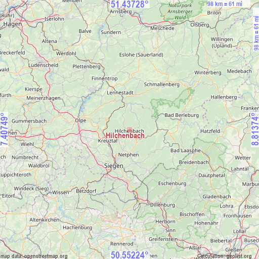
Hilchenbach GPS coordinates[2]
50° 59' 48.732" North, 8° 6' 38.232" East
| Map corner | latitude | longitude |
|---|---|---|
| Upper-left | 51.43728°, | 7.40749° |
| Center: | 50.99687°, | 8.11062° |
| Lower-right: | 50.55224°, | 8.81374° |
| Map W x H: | 98.4×98.4 km | = 61.1×61.1mi |
| max Lat: | 55.01917° ⇑42% North |
| Hilchenbach: | 50.99687° |
| min Lat: | ⇓58% South 47.40724° |
| min Long | Hilchenbach | max Long |
| 5.92978° | 8.11062° | 14.98853° |
| W 24.7%⇐ | ⇒75.3% E |
Elevation
Elevation of Hilchenbach is 357 m = 1171 ft, and this is 107.9 m = 354 ft above average elevation for this country.
| Max E: |
1256 m = 4121 ft | 30.1% |
| Hilchenbach | 357 m 1171 ft | |
| Avg. | 249.1 m = 817 ft | |
Min E: |
-5 m = -16 ft | 69.9% |
See also: Germany elevation on elevation.city.
Geographical zone
Hilchenbach is located in North temperate zone (between Tropic of Cancer and the Arctic Circle). Distance of this North polar circle is 1730.9 km =1075.5 mi to North.| Distance of | km | miles | from Hilchenbach |
|---|---|---|---|
| North Pole | 4336.7 | 2694.7 | to North |
| Arctic Circle | 1730.9 | 1075.5 | to North |
| Tropic Cancer | 3064.4 | 1904.1 | to South |
| Equator | 5670.3 | 3523.4 | to South |


Nearby cities:
15 places around Hilchenbach: (largest is in red/bold)
• Attendorn
20.4 km =12.7 mi,  314°
314°
• Bad Berleburg
20.6 km =12.8 mi,  72°
72°
• Bamenohl
20.7 km =12.9 mi,  334°
334°
• Erndtebrück
10 km =6.2 mi,  94°
94°
• Finnentrop
21.3 km =13.2 mi, 333°
• Freudenberg
19.9 km =12.4 mi,  236°
236°
• Kirchhundem
10 km =6.2 mi,  351°
351°
• Kreuztal
9.1 km =5.7 mi,  249°
249°
• Lennestadt
13.7 km =8.5 mi, 347°
• Netphen
8.9 km =5.5 mi,  184°
184°
• Olpe
18.5 km =11.5 mi,  281°
281°
• Schmallenberg
21.4 km =13.3 mi,  34°
34°
• Siegen
14.9 km =9.3 mi,  204°
204°
• Wenden
17.4 km =10.8 mi,  258°
258°
• Wilnsdorf
20.1 km =12.5 mi, 182°
Sources, notices
• [Note1] Compared only with cities in Germany existing in our database
• [Src1] Map data: © OpenStreetMap contributors (CC-BY-SA)
• [Src2] Other city data from geonames.org with taken over terms of usage.
• [Src3] Geographical zone / Annual Mean Temperature by Robert A. Rohde @ Wikipedia
