Kirchhundem geodata
Kirchhundem (North Rhine-Westphalia) is a seat of a fourth-order administrative division; located in Germany in Europe/Berlin (GMT+2) time zone. With population of 12,966 people, there are 1241 cities with bigger population in this country. Compared to other cities in Germany, 59.6% of cities are located further ↓South; 75.6% of cities are located further →East and 62.9% of cities have lower elevation than Kirchhundem. Note1
Administrative division(s):
- Level 1: North Rhine-Westphalia
- Level 2: Regierungsbezirk Arnsberg
- Level 3: Kreis Olpe
- Level 4: Kirchhundem


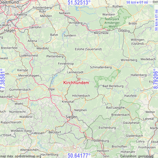
Kirchhundem GPS coordinates[2]
51° 5' 8.016" North, 8° 5' 20.148" East
| Map corner | latitude | longitude |
|---|---|---|
| Upper-left | 51.52513°, | 7.38581° |
| Center: | 51.08556°, | 8.08893° |
| Lower-right: | 50.64177°, | 8.79206° |
| Map W x H: | 98.2×98.2 km | = 61×61mi |
| max Lat: | 55.01917° ⇑40.4% North |
| Kirchhundem: | 51.08556° |
| min Lat: | ⇓59.6% South 47.40724° |
| min Long | Kirchhundem | max Long |
| 5.92978° | 8.08893° | 14.98853° |
| W 24.4%⇐ | ⇒75.6% E |
Elevation
Elevation of Kirchhundem is 308 m = 1010 ft, and this is 58.9 m = 193 ft above average elevation for this country.
| Max E: |
1256 m = 4121 ft | 37.1% |
| Kirchhundem | 308 m 1010 ft | |
| Avg. | 249.1 m = 817 ft | |
Min E: |
-5 m = -16 ft | 62.9% |
See also: Germany elevation on elevation.city.
Geographical zone
Kirchhundem is located in North temperate zone (between Tropic of Cancer and the Arctic Circle). Distance of this North polar circle is 1721 km =1069.4 mi to North.| Distance of | km | miles | from Kirchhundem |
|---|---|---|---|
| North Pole | 4326.9 | 2688.6 | to North |
| Arctic Circle | 1721 | 1069.4 | to North |
| Tropic Cancer | 3074.3 | 1910.3 | to South |
| Equator | 5680.2 | 3529.5 | to South |


Nearby cities:
15 places around Kirchhundem: (largest is in red/bold)
• Attendorn
13.7 km =8.5 mi,  289°
289°
• Bad Berleburg
21.5 km =13.4 mi,  99°
99°
• Bad Fredeburg
19.2 km =11.9 mi,  53°
53°
• Bamenohl
11.5 km =7.1 mi,  320°
320°
• Erndtebrück
15.7 km =9.8 mi,  133°
133°
• Eslohe
19.5 km =12.1 mi,  16°
16°
• Finnentrop
12.2 km =7.6 mi, 318°
• Hilchenbach
10 km =6.2 mi,  171°
171°
• Kreuztal
14.9 km =9.3 mi,  208°
208°
• Lennestadt
3.8 km =2.4 mi,  336°
336°
• Netphen
18.8 km =11.7 mi,  177°
177°
• Olpe
17.8 km =11.1 mi,  249°
249°
• Plettenberg
20.4 km =12.7 mi,  312°
312°
• Schmallenberg
15.7 km =9.8 mi,  60°
60°
• Wenden
20.4 km =12.7 mi,  229°
229°
Sources, notices
• [Note1] Compared only with cities in Germany existing in our database
• [Src1] Map data: © OpenStreetMap contributors (CC-BY-SA)
• [Src2] Other city data from geonames.org with taken over terms of usage.
• [Src3] Geographical zone / Annual Mean Temperature by Robert A. Rohde @ Wikipedia
