Kirkel geodata
Kirkel (Saarland) is a seat of a fourth-order administrative division; located in Germany in Europe/Berlin (GMT+2) time zone. With population of 10,330 people, there are 1588 cities with bigger population in this country. Compared to other cities in Germany, 79% of cities are located further ↑North; 91% of cities are located further →East and 53.4% of cities have lower elevation than Kirkel. Note1


Kirkel GPS coordinates[2]
49° 16' 59.988" North, 7° 13' 59.988" East
| Map corner | latitude | longitude |
|---|---|---|
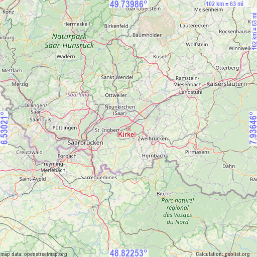
| Upper-left | 49.73986°, | 6.53021° |
| Center: | 49.28333°, | 7.23333° |
| Lower-right: | 48.82253°, | 7.93646° |
| Map W x H: | 102×102 km | = 63.4×63.4mi |
| max Lat: | 55.01917° ⇑79% North |
| Kirkel: | 49.28333° |
| min Lat: | ⇓21% South 47.40724° |
| min Long | Kirkel | max Long |
| 5.92978° | 7.23333° | 14.98853° |
| W 9%⇐ | ⇒91% E |
Elevation
Elevation of Kirkel is 249 m = 817 ft, and this is 0.099999999999994 m = 0 ft below average elevation for this country.
| Max E: |
1256 m = 4121 ft | 46.6% |
| Avg. | 249.1 m = 817 ft | |
| Kirkel | 249 m = 817 ft | |
Min E: |
-5 m = -16 ft | 53.4% |
See also: Germany elevation on elevation.city.
Geographical zone
Kirkel is located in North temperate zone (between Tropic of Cancer and the Arctic Circle). Distance of this North polar circle is 1921.4 km =1193.9 mi to North.| Distance of | km | miles | from Kirkel |
|---|---|---|---|
| North Pole | 4527.3 | 2813.1 | to North |
| Arctic Circle | 1921.4 | 1193.9 | to North |
| Tropic Cancer | 2873.9 | 1785.8 | to South |
| Equator | 5479.8 | 3405 | to South |


Nearby cities:
15 places around Kirkel: (largest is in red/bold)
• Althornbach
13.6 km =8.5 mi,  130°
130°
• Bexbach
7.2 km =4.5 mi,  12°
12°
• Blieskastel
5.4 km =3.4 mi,  162°
162°
• Friedrichsthal
11.1 km =6.9 mi,  296°
296°
• Großbundenbach
13.4 km =8.3 mi,  82°
82°
• Hangard
11.2 km =7 mi,  351°
351°
• Homburg
9 km =5.6 mi,  57°
57°
• Neunkirchen
7.8 km =4.8 mi,  330°
330°
• Rimschweiler
12.6 km =7.8 mi,  124°
124°
• Sankt Ingbert
8.5 km =5.3 mi,  265°
265°
• Schiffweiler
11.8 km =7.3 mi,  321°
321°
• Spiesen-Elversberg
8.1 km =5 mi, 297°
• Sulzbach
12.9 km =8 mi,  277°
277°
• Waldmohr
13.3 km =8.3 mi,  33°
33°
• Zweibrücken
10.7 km =6.6 mi,  112°
112°
Sources, notices
• [Note1] Compared only with cities in Germany existing in our database
• [Src1] Map data: © OpenStreetMap contributors (CC-BY-SA)
• [Src2] Other city data from geonames.org with taken over terms of usage.
• [Src3] Geographical zone / Annual Mean Temperature by Robert A. Rohde @ Wikipedia
