Bexbach geodata
Bexbach (Saarland) is a populated place; located in Germany in Europe/Berlin (GMT+2) time zone. With population of 19,115 people, there are 818 cities with bigger population in this country. Compared to other cities in Germany, 78% of cities are located further ↑North; 90.6% of cities are located further →East and 53.6% of cities have lower elevation than Bexbach. Note1


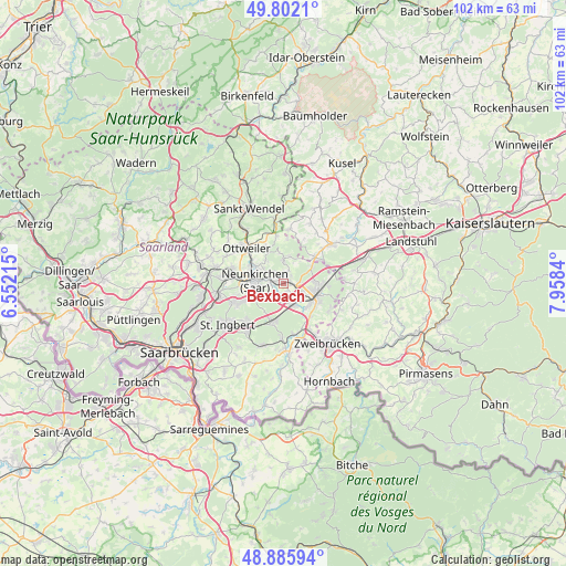
Bexbach GPS coordinates[2]
49° 20' 46.14" North, 7° 15' 18.972" East
| Map corner | latitude | longitude |
|---|---|---|
| Upper-left | 49.8021°, | 6.55215° |
| Center: | 49.34615°, | 7.25527° |
| Lower-right: | 48.88594°, | 7.9584° |
| Map W x H: | 101.9×101.9 km | = 63.3×63.3mi |
| max Lat: | 55.01917° ⇑78% North |
| Bexbach: | 49.34615° |
| min Lat: | ⇓22% South 47.40724° |
| min Long | Bexbach | max Long |
| 5.92978° | 7.25527° | 14.98853° |
| W 9.4%⇐ | ⇒90.6% E |
Elevation
Elevation of Bexbach is 250 m = 820 ft, and this is 0.90000000000001 m = 3 ft above average elevation for this country.
| Max E: |
1256 m = 4121 ft | 46.4% |
| Bexbach | 250 m 820 ft | |
| Avg. | 249.1 m = 817 ft | |
Min E: |
-5 m = -16 ft | 53.6% |
See also: Germany elevation on elevation.city.
Geographical zone
Bexbach is located in North temperate zone (between Tropic of Cancer and the Arctic Circle). Distance of this North polar circle is 1914.4 km =1189.6 mi to North.| Distance of | km | miles | from Bexbach |
|---|---|---|---|
| North Pole | 4520.3 | 2808.8 | to North |
| Arctic Circle | 1914.4 | 1189.6 | to North |
| Tropic Cancer | 2880.9 | 1790.1 | to South |
| Equator | 5486.8 | 3409.3 | to South |


Nearby cities:
15 places around Bexbach: (largest is in red/bold)
• Altenkirchen
11.8 km =7.3 mi,  23°
23°
• Bechhofen
10.5 km =6.5 mi,  87°
87°
• Breitenbach
9.7 km =6 mi,  4°
4°
• Dittweiler
11 km =6.8 mi,  31°
31°
• Dunzweiler
8.6 km =5.3 mi, 25°
• Friedrichsthal
11.7 km =7.3 mi,  259°
259°
• Hangard
5.2 km =3.2 mi,  321°
321°
• Homburg
6.4 km =4 mi,  110°
110°
• Kirkel
7.2 km =4.5 mi,  192°
192°
• Neunkirchen
5.4 km =3.4 mi,  268°
268°
• Ottweiler
9 km =5.6 mi,  312°
312°
• Schiffweiler
9.1 km =5.7 mi,  284°
284°
• Schönenberg-Kübelberg
10.9 km =6.8 mi,  51°
51°
• Spiesen-Elversberg
9.4 km =5.8 mi,  249°
249°
• Waldmohr
7 km =4.3 mi, 53°
Sources, notices
• [Note1] Compared only with cities in Germany existing in our database
• [Src1] Map data: © OpenStreetMap contributors (CC-BY-SA)
• [Src2] Other city data from geonames.org with taken over terms of usage.
• [Src3] Geographical zone / Annual Mean Temperature by Robert A. Rohde @ Wikipedia
