Holzdorf geodata
Holzdorf (Saxony-Anhalt) is a populated place; located in Germany in Europe/Berlin (GMT+2) time zone. With population of 1,324 people, there are 6236 cities with bigger population in this country. Compared to other cities in Germany, 69.7% of cities are located further ↓South; 93.2% of cities are located further ←West and 71.8% of cities have higher elevation than Holzdorf. Note1
Administrative division(s):
- Level 1: Saxony-Anhalt
- Level 3: Landkreis Wittenberg
- Level 4: Jessen (Elster)


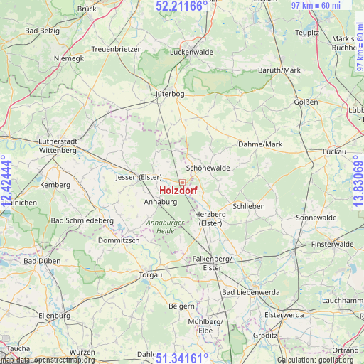
Holzdorf GPS coordinates[2]
51° 46' 43.428" North, 13° 7' 39.216" East
| Map corner | latitude | longitude |
|---|---|---|
| Upper-left | 52.21166°, | 12.42444° |
| Center: | 51.77873°, | 13.12756° |
| Lower-right: | 51.34161°, | 13.83069° |
| Map W x H: | 96.7×96.7 km | = 60.1×60.1mi |
| max Lat: | 55.01917° ⇑30.3% North |
| Holzdorf: | 51.77873° |
| min Lat: | ⇓69.7% South 47.40724° |
| min Long | Holzdorf | max Long |
| 5.92978° | 13.12756° | 14.98853° |
| W 93.2%⇐ | ⇒6.8% E |
Elevation
Elevation of Holzdorf is 79 m = 259 ft, and this is 170.1 m = 558 ft below average elevation for this country.
| Max E: |
1256 m = 4121 ft | 71.8% |
| Avg. | 249.1 m = 817 ft | |
| Holzdorf | 79 m = 259 ft | |
Min E: |
-5 m = -16 ft | 28.2% |
See also: Germany elevation on elevation.city.
Geographical zone
Holzdorf is located in North temperate zone (between Tropic of Cancer and the Arctic Circle). Distance of this North polar circle is 1643.9 km =1021.5 mi to North.| Distance of | km | miles | from Holzdorf |
|---|---|---|---|
| North Pole | 4249.8 | 2640.7 | to North |
| Arctic Circle | 1643.9 | 1021.5 | to North |
| Tropic Cancer | 3151.3 | 1958.1 | to South |
| Equator | 5757.3 | 3577.4 | to South |


Nearby cities:
15 places around Holzdorf: (largest is in red/bold)
• Annaburg
7.5 km =4.7 mi,  227°
227°
• Axien
18.6 km =11.6 mi,  242°
242°
• Dahme
23 km =14.3 mi,  63°
63°
• Dommitzsch
23 km =14.3 mi, 228°
• Elster
21.6 km =13.4 mi,  285°
285°
• Falkenberg
22.9 km =14.2 mi,  159°
159°
• Herzberg
12 km =7.5 mi,  148°
148°
• Ihlow
17.5 km =10.9 mi, 55°
• Jessen
11.8 km =7.3 mi,  277°
277°
• Klöden
20.4 km =12.7 mi,  264°
264°
• Lebusa
20.2 km =12.6 mi,  84°
84°
• Linda
8.8 km =5.5 mi,  349°
349°
• Prettin
19.2 km =11.9 mi, 226°
• Schlieben
18.6 km =11.6 mi,  109°
109°
• Seyda
18.9 km =11.7 mi,  307°
307°
Sources, notices
• [Note1] Compared only with cities in Germany existing in our database
• [Src1] Map data: © OpenStreetMap contributors (CC-BY-SA)
• [Src2] Other city data from geonames.org with taken over terms of usage.
• [Src3] Geographical zone / Annual Mean Temperature by Robert A. Rohde @ Wikipedia
